Texas State Highway Spur 86
Texas State Highway Spur 86 or Spur 86 is a short spur road in Bowie County, maintained by the Texas Department of Transportation (TxDOT). The route connects Interstate 30 to U.S. Highway 82 near Hooks, and provides access from Interstate 30 to the Red River Army Depot.
| ||||
|---|---|---|---|---|

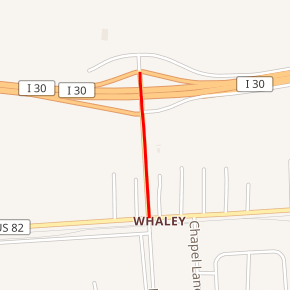
Spur 86 highlighted in red | ||||
| Route information | ||||
| Maintained by TxDOT | ||||
| Length | 0.404 mi[1] (0.650 km) | |||
| Existed | 1961–present | |||
| Major junctions | ||||
| South end | ||||
| North end | ||||
| Highway system | ||||
| ||||
Route description
Spur 86 begins at an intersection with US 82 at the main entrance to the Red River Army Depot in Whaley, Bowie County. From this point, the highway heads north as a four-lane undivided road through wooded areas with some development. Spur 86 comes to an interchange with I-30, where it ends.[1][2][3]
History
A previous routing of Spur 86 existed from January 27, 1940 to January 30, 1951, and connected SH 6 to the Administration Building of Texas A&M University (then known as A&M College) in Brazos County. This route was previously SH 224. The current incarnation of Spur 86 was designated on November 30, 1961.[1]
Major intersections
The entire route is in Whaley, Bowie County.
| mi[1] | km | Destinations | Notes | ||
|---|---|---|---|---|---|
| 0.000 | 0.000 | ||||
| 0.404 | 0.650 | I-30 exit 206 | |||
| 1.000 mi = 1.609 km; 1.000 km = 0.621 mi | |||||
References
- Transportation Planning and Programming Division (n.d.). "State Highway Spur No. 86". Highway Designation Files. Texas Department of Transportation. Retrieved July 15, 2010.
- Transportation Planning and Programming Division (2014). Texas County Mapbook (PDF) (Map) (2014 ed.). 1:120,000. Texas Department of Transportation. p. 521. Retrieved December 4, 2014.
- Google (October 10, 2011). "Overview Map: Texas State Highway Spur 86" (Map). Google Maps. Google. Retrieved October 10, 2011.
