Texas State Highway 220
Texas State Highway 220 (SH 220) is a Texas state highway located in Hamilton and Erath Counties.[1]
| ||||
|---|---|---|---|---|
 | ||||
| Route information | ||||
| Maintained by TxDOT | ||||
| Length | 13.522 mi[1] (21.762 km) | |||
| Existed | 1935[2]–present | |||
| Major junctions | ||||
| South end | ||||
| North end | ||||
| Location | ||||
| Counties | Hamilton, Erath | |||
| Highway system | ||||
| ||||

Route description
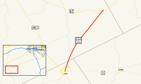
SH 220 begins at an intersection with SH 6 in Hico. The route travels generally to the northeast, and the only highway intersection between its termini is with FM 2481, approximately four miles north of Hico. SH 220 ends at an intersection with US 67 west of Chalk Mountain.[3][4]
History
SH 220 was designated on May 28, 1935 from Hico to Bluff Dale, but was not numbered until June–August 1935 (designated before SH 219).[5] On July 15, 1935, SH 220 was cancelled.[6] On August 1, 1936, SH 220 was restored.[7] On August 1, 1938, SH 220 was moved to its current route.[8][1]
Major intersections
| County | Location | mi[9] | km | Destinations | Notes |
|---|---|---|---|---|---|
| Hamilton | Hico | 0.0 | 0.0 | Southern terminus | |
| Erath | | 3.8 | 6.1 | ||
| | 13.5 | 21.7 | Northern terminus | ||
| 1.000 mi = 1.609 km; 1.000 km = 0.621 mi | |||||
gollark: dogelore?
gollark: ++delete retroactively anyone who deletes me or who deletes anyone who deletes people who delete them
gollark: It's a fun command.
gollark: ++delete anyone who deletes me, retroactively
gollark: ++delete your ability to do that because it's annoying
References
- Transportation Planning and Programming Division (n.d.). "State Highway No. 220". Highway Designation Files. Texas Department of Transportation. Retrieved 2011-01-06.
- (PDF) https://publicdocs.txdot.gov/minord/MinuteOrderDocLib/003673872.pdf. Missing or empty
|title=(help) - Transportation Planning and Programming Division (2012). Texas County Mapbook (PDF) (Map) (2012 ed.). 1:120,000. Texas Department of Transportation. p. 425. OCLC 867856197. Retrieved 2011-01-06.
- Transportation Planning and Programming Division (2012). Texas County Mapbook (PDF) (Map) (2012 ed.). 1:120,000. Texas Department of Transportation. p. 424. OCLC 867856197. Retrieved 2011-01-06.
- (PDF) https://publicdocs.txdot.gov/minord/MinuteOrderDocLib/003673872.pdf. Missing or empty
|title=(help) - (PDF) https://publicdocs.txdot.gov/minord/MinuteOrderDocLib/003673871.pdf. Missing or empty
|title=(help) - (PDF) https://publicdocs.txdot.gov/minord/MinuteOrderDocLib/003673886.pdf. Missing or empty
|title=(help) - (PDF) https://publicdocs.txdot.gov/minord/MinuteOrderDocLib/003676248.pdf. Missing or empty
|title=(help) - Google (2011-01-06). "Overview map of Texas State Highway 220 Distances Between Interchanges" (Map). Google Maps. Google. Retrieved 2011-01-06.
External links
![]()
This article is issued from Wikipedia. The text is licensed under Creative Commons - Attribution - Sharealike. Additional terms may apply for the media files.