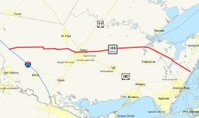
Texas State Highway 188
State Highway 188 (SH 188) is a state highway in the Coastal Bend region of Texas. It runs 41.327 miles (66.509 km) from Mathis east to the Gulf of Mexico near Port Aransas. SH 188 was established in its current form in 1992, after a previous incarnation existed from 1932 to 1942.
| ||||
|---|---|---|---|---|
 | ||||
| Route information | ||||
| Maintained by TxDOT | ||||
| Length | 41.327 mi[1] (66.509 km) Excludes length of US 181 overlap in Sinton | |||
| Existed | 1993–present | |||
| Major junctions | ||||
| West end | ||||
| ||||
| East end | ||||
| Highway system | ||||
| ||||
History
Previous route
SH 188 was previously designated on November 30, 1932, as a connector route between then-SH 5 and Roxton.[2] This route was canceled on April 29, 1942, and was replaced by FM 38.
Current route
SH 188 was designated on December 22, 1992, replacing part of FM 881 and part of FM 1069, of which SH 188 was concurrent with. On June 29, 1993, SH 188 was extended 1.8 miles (2.9 km) over another part of FM 1069, canceling the section of FM 1069 east of the junction with SH 188, transferring it to SH 188, and the remainder of FM 881 was redesignated as part of FM 1069.[1]
Major intersections
| County | Location | mi | km | Destinations | Notes |
|---|---|---|---|---|---|
| San Patricio | | I‑37 exit 31; western terminus. | |||
| | |||||
| | |||||
| Sinton | |||||
| West end of US 181 & Bus. US 77 overlaps | |||||
| East end of Bus. US 77 overlap | |||||
| East end of US 181 overlap | |||||
| | |||||
| | |||||
| Aransas | | ||||
| | |||||
| | Eastern terminus | ||||
1.000 mi = 1.609 km; 1.000 km = 0.621 mi
| |||||
References
- Transportation Planning and Programming Division (n.d.). "State Highway No. 188". Highway Designation Files. Texas Department of Transportation. Retrieved January 30, 2016.
- (PDF) https://publicdocs.txdot.gov/minord/MinuteOrderDocLib/003673821.pdf. Missing or empty
|title=(help)
