Texas State Highway 173
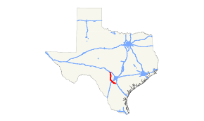
State Highway 173 (SH 173) is a state highway that runs for 97.9 miles (157.6 km) from Jourdanton to Kerrville in south Texas, traversing through the Texas Hill Country.
| ||||
|---|---|---|---|---|
| 173rd Airborne Brigade Memorial Highway | ||||
 | ||||
| Route information | ||||
| Maintained by TxDOT | ||||
| Length | 97.34 mi[1][nb 1] (156.65 km) | |||
| Existed | 1932–present | |||
| Major junctions | ||||
| South end | ||||
| North end | ||||
| Location | ||||
| Counties | Atascosa, Frio, Medina, Bandera, Kerr | |||
| Highway system | ||||
| ||||

History
The highway was originally designated on August 4, 1932 from Hondo southeast to Devine.[2] On October 26, 1932, it extended southeast to Pleasanton.[3] On January 11, 1933, it was rerouted to end in Jourdanton.[4] On October 16, 1933, this section from Devine to Jourdanton was cancelled.[5] On May 14, 1935, it extended back to Jourdanton.[6] On July 15, 1935, SH 173 was cancelled.[7] On September 3, 1935, a road from Devine to Jourdanton was being investigated for preparation for restoration of this section of SH 173. On April 20, 1936, the entire route was restored.[8] On September 26, 1939, the designated route was extended south from Jourdanton through Freer, absorbing most of SH 241, with an expected terminus at Hebbronville.[9] on January 29, 1942, the section from Freer to Hebbronville had been cancelled. On August 31, 1965, the section south of Jourdanton was transferred to SH 16. On February 21, 1972, SH 173 was signed, but not designated along FM 689 to Kerrville. On October 23, 1978, the section west of Loop 534 was transferred to Loop 534, but still signed as SH 173.. On August 29, 1990, the route was extended northward to Kerrville, replacing FM 689.[10]
Route description
SH 173 begins at SH 16 just north of Jourdanton. SH 173 runs northwest toward Devine where it intersects I-35 in the south part of town. Leaving Devine, 173 turns running in a sharper northwest direction. Just east of Hondo, the highway interchanges with US 90. The highway turns to run in a more north-south direction, twisting and turning many times through canyons. SH 173 enters Bandera and intersects SH 16 for a second time. The two highways share a short overlap before splitting. Here, signs are posted advising trucks and through traffic to use SH 173 as a route to Kerrville instead of SH 16, as SH 173 is a shorter and faster route, while SH 16 traverses a hill with many sharp curves. SH 173 intersects SH 16 for a third time in Kerrville, where the highway ends.
Junction list
| County | Location | mi[11] | km | Destinations | Notes |
|---|---|---|---|---|---|
| Atascosa | Jourdanton | 0.0 | 0.0 | Southern terminus of SH 173 | |
| | 6.0 | 9.7 | South end of FM 2146 overlap | ||
| | 6.3 | 10.1 | North end of FM 2146 overlap | ||
| | 9.8 | 15.8 | |||
| | 15.2 | 24.5 | Southern terminus of FM 2504 | ||
| Frio | Bigfoot | 21.5 | 34.6 | ||
| Medina | Devine | 24.9 | 40.1 | I-35 exit 122. | |
| 25.7 | 41.4 | ||||
| 25.8 | 41.5 | ||||
| 26.6 | 42.8 | Eastern terminus of FM 2200 | |||
| | 30.7 | 49.4 | Southern terminus of FM 1343 | ||
| | 45.7 | 73.5 | Interchange | ||
| | 45.8 | 73.7 | 18th Street | Interchange | |
| | 47.0 | 75.6 | Western terminus of FM 2676 | ||
| Bandera | | 72.9 | 117.3 | ||
| Bandera | 73.3 | 118.0 | South end of SH 16 overlap | ||
| 73.8 | 118.8 | North end of SH 16 overlap | |||
| | 74.3 | 119.6 | Eastern terminus of FM 3240 | ||
| | 84.0 | 135.2 | |||
| Kerr | Camp Verde | 86.6 | 139.4 | Southern terminus of RM 480 | |
| | 92.0 | 148.1 | Eastern terminus of FM 2771 | ||
| Kerrville | 95.8 | 154.2 | Southern terminus of Loop 534 | ||
| 97.9 | 157.6 | Northern terminus of SH 173; access to Peterson Regional Medical Center | |||
1.000 mi = 1.609 km; 1.000 km = 0.621 mi
| |||||
Notes
References
- Transportation Planning and Programming Division (n.d.). "State Highway No. 173". Highway Designation Files. Texas Department of Transportation. Retrieved June 27, 2018.
- (PDF) https://publicdocs.txdot.gov/minord/MinuteOrderDocLib/003673821.pdf. Missing or empty
|title=(help) - (PDF) https://publicdocs.txdot.gov/minord/MinuteOrderDocLib/003673818.pdf. Missing or empty
|title=(help) - (PDF) https://publicdocs.txdot.gov/minord/MinuteOrderDocLib/003673824.pdf. Missing or empty
|title=(help) - (PDF) https://publicdocs.txdot.gov/minord/MinuteOrderDocLib/003673837.pdf. Missing or empty
|title=(help) - (PDF) https://publicdocs.txdot.gov/minord/MinuteOrderDocLib/003673872.pdf. Missing or empty
|title=(help) - (PDF) https://publicdocs.txdot.gov/minord/MinuteOrderDocLib/003673871.pdf. Missing or empty
|title=(help) - (PDF) https://publicdocs.txdot.gov/minord/MinuteOrderDocLib/003673881.pdf. Missing or empty
|title=(help) - Transportation Planning and Programming Division (n.d.). "State Highway No. 241". Highway Designation Files. Texas Department of Transportation. Retrieved July 3, 2017.
- Transportation Planning and Programming Division (n.d.). "Farm to Market Road No. 689". Highway Designation Files. Texas Department of Transportation. Retrieved July 3, 2017.
- Google (June 27, 2018). "Overview map of State Highway 173" (Map). Google Maps. Google. Retrieved June 27, 2018.