Territorial disputes of India and Nepal
Major areas of dispute between India and Nepal are Kalapani territory, Limpiyadhura, Susta, Mechi, Tanakpur[1] and Kuthi Valley.
Limpiyadhura, Lipulekh and Kalapani
Nepal claims that the river to the west of Kalapani as the main Kali River, hence claims these regions to be a part of Nepal.[2][3][4] The river borders the Nepalese district of Darchula in the Sudurpashchim Pradesh province and the Indian district of Pithoragarh in Uttarakhand state. The Treaty of Sugauli signed by Nepal and British India on 3 March 1816[5] locates the Kali River as Nepal's western boundary with India. (Wikisource:Treaty of Sugauli)
Subsequent maps drawn by British surveyors show the source of the boundary river at different places. This discrepancy in locating the source of the river led to boundary disputes between India and Nepal, with each country producing maps supporting their own claims. The Kali River runs through an area that includes a disputed area of about 400 km2 around the source of the river, although the exact size of the disputed area varies from source to source. Kalapani has been controlled by India's Indo-Tibetan Border Police since the Sino-Indian War with China in 1962.[6]
In November 2019, there was a protest in Kathmandu opposing a new map of India showing Kalapani as part of Indian state of Uttarakhand.[7] On 20 May 2020, Nepal launched its own map showing Kalapani as parts of its own territory.[8] On 10 June, the Nepali parliament moved to approve a new map and revision of the national emblem which includes territory in India's Uttarakhand state.[9] On 18 June, the upper house of Nepal's parliament approved a new map for the country which included territories controlled by India. India opposed the move, saying that the decision to include Limpiyadhura, Lipulekh and Kalapani is not based on evidence or historical facts.[10] On 19 June, Nepal started deploying its troops near the Kalapani and other disputed areas. The troops had established camps and they were working on building a helipad in the area.[11] In the same month Nepali Army Chief, General Purna Chandra Thapa, after visiting Kalapani border area, stated that Nepali army will start building army barracks and border outposts near the Kalapani area.[12]
Susta

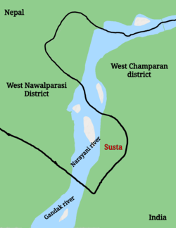
Susta is another territory which is disputed between Nepal and India. It currently controlled by India and is a part of Bihar province. Residents of a village in Susta state that Susta belongs to Nepal and they are Nepali citizens.[13] The 1816 Treaty of Sugauli defined the Gandaki River as the international boundary between India and Nepal. The right bank of Gandaki river was under Nepal’s control while the left bank was under India's control. Susta village was initially on the right side when the treaty was signed and it was a part of Nepal. However, over the years, the Gandaki river changed its course and Susta moved to the left bank and is now currently under India's control.[13] Government of Nepal has repeatedly stated that Susta belongs to Nepal and Indian government should return the area.
Border encroachments
India shares a border with Nepal from three sides. Many Nepalese media have reported cases of border encroachments on the part of Indian parties in multiple border regions.[14] Nepal claims that among 27 districts that share their border with Nepal, 72 places in 23 districts have been encroached.[15][16]
On 15 June 2020, Indian border police, Sashastra Seema Bal (SSB) reported that border pillars which served as demarcation, were missing along the India-Nepal border. SSB also reported that Nepali border police has established five new border outpost near the disputed area.[17]
See also
References
- "India and Nepal's Slow-Motion Border Dispute". The Diplomat. 4 January 2020.
- "The World Factbook".
- "Defining Himalayan borders an uphill battle". thefreelibrary.com. Retrieved 22 December 2013.
- "The Kalapani dispute: All you need to know". Times of India. Retrieved 21 March 2020.
- Panta, Ś. D. (2006). Nepal-India border problems. Dr. Shastra Dutta Pant Institute for Rural Development, Kathmandu.
- "India's Boundary Disputes with China, Nepal, and Pakistan". International Boundary Consultants website. Retrieved 23 March 2007.
- "India's updated political map stirs controversy in Nepal". www.aljazeera.com.
- Bhattacherjee, Kallol (20 May 2020). "Nepal's new political map claims India's territories" – via www.thehindu.com.
- "Nepal Parliament moves to approve new map". The Times of India. 10 June 2020.
- "Nepal Parliament approves new map that includes land India claims". Al Jazeera. 18 June 2020.
- "In a first, Nepal deploys its troops at border with India". India Today. 19 June 2020.
- "Nepal to set up army barrack, border outpost near Kalapani after getting controversial new map". theprint.in. 19 June 2020.
- "As a river changed its course, a village on the India-Nepal border became disputed territory". scroll.in. 19 March 2017.
- "भरतीय पक्षबाट नेपाली सीमा अतिक्रमण भएको स्वीकार". Kantipur TV.
- "भारतसंग सीमा जोडिएका २७ जिल्ला मध्ये २३ जिल्लाका ७२ स्थानमा सीमा अतिक्रमण". Mountain TV. Retrieved 18 November 2019.
- "India and Nepal's Slow-Motion Border Dispute". 4 January 2020. Retrieved 21 March 2020.
- "India-Nepal border posts missing: SSB". Times of India. 15 June 2020.