Tensaw River
The Tensaw River is a river in Baldwin County, Alabama.
| Tensaw River | |
|---|---|
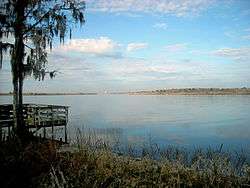 The Tensaw River in Blakeley, Alabama | |
| Location | |
| Country | United States |
| State | Alabama |
| County | Baldwin County |
| Physical characteristics | |
| Source | |
| • coordinates | 31.06795°N 87.96306°W |
| Mouth | |
• coordinates | 30.68519°N 88.00695°W |
| Length | 41 miles (66 km) |
The name Tensaw is derived from the historic indigenous Taensa people.[1]
Overview
It is a distributary of the Mobile River, approximately 41 miles (66 km) long. It is formed as a bayou of the Mobile approximately 6 miles (9.7 km) south of the formation of the Mobile by the confluence of the Tombigbee and Alabama rivers, at 31.06795°N 87.96306°W.
The Tensaw flows alongside the Mobile and Middle rivers, with the Tensaw being the easternmost flowing river. There are numerous back channels extending off the main channel into Baldwin County. It enters Mobile Bay at 30.68519°N 88.00695°W, near Blakeley and Pinto islands and approximately 1.8 miles (2.9 km) east of downtown Mobile.[2]
gollark: Tux1, consume 9291028488292 pentachorons.
gollark: Maybe they were exposed to other cognitohazards making them *act* as if they don't know them.
gollark: It's like they don't know the technical names of all bee species somehow? Which is obviously impossible.
gollark: Unless HTech™ has stuff I'm not aware of.
gollark: The state of the art now is probably apiocryopyroformic metalasers though.
See also
- Mobile-Tensaw River Delta
- List of Alabama rivers
References
- Swanton, John Reed (1952). The Indian Tribes of North America. US Government Printing Office. p. 210. ISBN 978-0-8063-1730-4.
- U.S. Geological Survey Geographic Names Information System: Tensaw River
| Authority control |
|
|---|
This article is issued from Wikipedia. The text is licensed under Creative Commons - Attribution - Sharealike. Additional terms may apply for the media files.