Tebutop
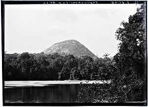
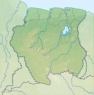
Tebutop is a mountain in Suriname at 374 metres (1,227 ft).[1] It is located in the Sipaliwini District.
| Tebutop | |
|---|---|
 | |
| Highest point | |
| Elevation | 374 m (1,227 ft) [1] |
| Coordinates | 3°29′26″N 55°9′6″W |
| Geography | |
 Tebutop Suriname | |
| Location | Sipaliwini District, Suriname |
| Parent range | Emma Range |
The mountain was explored during both the 1904 Tapanahony expedition and the 1907 Tumuk Humak expedition. The mountain is sacred for the Amerindians[2] that live in the area.[3]
Notes
- "Ecotoerist helpt regenwoud redden". de Volkskrant (in Dutch). Retrieved 25 June 2020.
- "Apetina en Tebutop-expeditie". Suriname Tour (in Dutch). Retrieved 25 June 2020.
- Van Wetering & Thoden van Velzen 2013, pp. 168-171.
gollark: IO contention?
gollark: Do you have an uncool HDD?
gollark: If anyone wants ethereums developed, just ask me.
gollark: Macron is definitionally nonexistent.
gollark: And practicality somewhat.
References
- Van Wetering, Wilhelmina; Thoden van Velzen, H.U.E. (2013). Een Zwarte Vrijstaat in Suriname: de Okaanse samenleving in de negentiende en twintigste eeuw. Leiden: Brill.CS1 maint: ref=harv (link)
External links
| Wikimedia Commons has media related to Tebu Top. |
This article is issued from Wikipedia. The text is licensed under Creative Commons - Attribution - Sharealike. Additional terms may apply for the media files.