Taylor County Airport (Kentucky)
Taylor County Airport (ICAO: KAAS, FAA LID: AAS) is a county-owned public-use airport located two nautical miles (4 km) northeast of the central business district of Campbellsville, a city in Taylor County, Kentucky, United States.[1]
Taylor County Airport | |||||||||||
|---|---|---|---|---|---|---|---|---|---|---|---|
 | |||||||||||
| Summary | |||||||||||
| Airport type | Public | ||||||||||
| Owner | Taylor County Airport Board | ||||||||||
| Location | Campbellsville, Kentucky | ||||||||||
| Elevation AMSL | 921 ft / 281 m | ||||||||||
| Coordinates | 37°21′30″N 085°18′34″W | ||||||||||
| Runways | |||||||||||
| |||||||||||
| Statistics (2006) | |||||||||||
| |||||||||||
Although most U.S. airports use the same three-letter location identifier for the FAA and IATA, Taylor County Airport is assigned AAS by the FAA but has no designation from the IATA[2] (which assigned AAS to Apalapsili Airport in Apalapsili, Indonesia).[3]
Facilities and aircraft
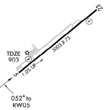
Taylor County Airport covers an area of 106 acres (43 ha) at an elevation of 921 feet (281 m) above mean sea level. It has one asphalt paved runway designated 5/23 which measures 5,003 x 75 feet (1,525 x 23 m). For the 12-month period ending May 19, 2006, the airport had 10,200 aircraft operations, an average of 27 per day: 75% general aviation, 16% air taxi and 9% military.[1]
References
External links
- FAA Terminal Procedures for AAS, effective July 16, 2020
- Resources for this airport:
- FAA airport information for AAS
- AirNav airport information for AAS
- FlightAware airport information and live flight tracker
- SkyVector aeronautical chart for AAS