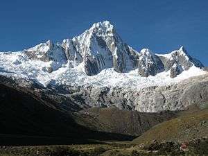
Taulliraju
Taulliraju[1][2] (possibly from Quechua tawlli a kind of legume,[3] rahu snow, ice, mountain with snow,[4]) is a mountain in the Cordillera Blanca in the Andes of Peru, about 5,830 metres (19,127 ft) high[2] (other sources cite 6,303 metres (20,679 ft) of elevation).[1] It is located between the provinces of Huaylas and Pomabamba in the region of Ancash. Taulliraju lies inside Huascarán National Park, south east of Pucajirca and east of Rinrijirca.[1]
| Taulliraju | |
|---|---|
 | |
| Highest point | |
| Elevation | 5,830 m (19,130 ft) |
| Coordinates | 8°53′33″S 77°34′45″W |
| Geography | |
 Taulliraju Peru | |
| Location | Ancash, Peru |
| Parent range | Andes, Cordillera Blanca |
Climbing
There are a number of routes, but there is no easy way to climb this spectacular mountain. The easier two are perhaps the south-southeast ridge or the north face; all the other routes are more difficult. The south-southeast ridge and the north face are rated TD-, the south buttress is TD, the southwest face is ED1 and the east buttress is ED1/ED2.
The east buttress on the southwest face, known also as Fowler-Watts route was climbed on the 26 May 1982 and since has defeated many competent parties. It is a serious undertaking on mixed ground, steep sections of rock (difficulty UIAA V+) with key passages at A3+ and vertical rotten ice. A variation of the Fowler-Watts route is the Sykes-Clay, climbed on 10 July 1989 and rarely repeated since.
The 1-km long west ridge was climbed on the 26 June 2016 by a New Zealand team comprising Pearson, McDowell, Fortune and Measures. The route took five days round-trip from the base camp with three bivvys on the ridge, and involved difficulties up to M5, WI4 and UIAA VI-.
See also
- Sentilo
- Tawlliqucha
- Santa Cruz Creek
References
- Peru 1:100 000, Corongo (18-h). IGN (Instituto Geográfico Nacional - Perú).
- Alpenvereinskarte 0/3a. Cordillera Blanca Nord (Peru). 1:100 000. Oesterreichischer Alpenverein. 2005. ISBN 3-928777-57-2.
- Ana Arias Torre, Toponimia de Ticabamba, in LETRAS, Órgano de la Facultad de Letras y Ciencias Humanas , Universidad Nacional Mayor de San Marcos, Lima 2002: tawlli - Tipo de legumbre, muy parecido al chocho
- babylon.com Archived 2014-12-29 at the Wayback Machine
External links
| Wikimedia Commons has media related to Taulliraju. |