Tatlayoko Lake, British Columbia
Tatlayoko Lake is an unincorporated settlement and locality on the Homathko River just north of that river's entry into the lake of same name,[1] which is located in the western Chilcotin Country of the Central Interior of British Columbia, Canada.
Tatlayoko Lake | |
|---|---|
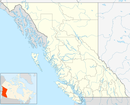 Tatlayoko Lake Location of Tatlayoko Lake in British Columbia  Tatlayoko Lake Tatlayoko Lake (Canada) | |
| Coordinates: 51°39′54″N 124°24′06″W | |
| Country | Canada |
| Province | British Columbia |
Climate
The name Tatlayoko is derived from the Tsilhqot'in language and means "lake of the big winds." [2] True to its name, the community is windy throughout the fall and winter as the warm Chinook winds blow up the valley. The Chilcotin Plateau is known for being extremely cold in the winter, but Tatlayoko Lake is an exception thanks to its proximity to the mild Pacific Ocean. While the coastal winds bring the community relatively mild winters, the mountains block most of the coastal precipitation, leaving the community comparatively dry.
In relation to the nearby community of Tatla Lake and indeed the rest of the Chilcotin Plateau off to the east, Tatlayoko Lake tends to be wetter in the winter and drier in the summer. Tatlayoko Lake has a continental climate (Dfb), bordering on a subarctic climate (Dfc).
Weather facts
- Driest Year (2002) = 264 mm (10 in)
- Wettest Year (1950) = 626 mm (25 in)
- Warmest Year (1941) = 5.9 °C (43 °F)
- Coldest Year (1957) = 2.2 °C (36 °F)
| Climate data for Tatlayoko Lake | |||||||||||||
|---|---|---|---|---|---|---|---|---|---|---|---|---|---|
| Month | Jan | Feb | Mar | Apr | May | Jun | Jul | Aug | Sep | Oct | Nov | Dec | Year |
| Record high °C (°F) | 15.6 (60.1) |
17.8 (64.0) |
21.4 (70.5) |
29.4 (84.9) |
33.5 (92.3) |
33.1 (91.6) |
37.8 (100.0) |
33.9 (93.0) |
32.2 (90.0) |
27.8 (82.0) |
18.3 (64.9) |
15 (59) |
37.8 (100.0) |
| Average high °C (°F) | −0.7 (30.7) |
3.0 (37.4) |
7.2 (45.0) |
11.8 (53.2) |
16.1 (61.0) |
19.3 (66.7) |
22.4 (72.3) |
22.7 (72.9) |
18.6 (65.5) |
11.5 (52.7) |
3.1 (37.6) |
−1.6 (29.1) |
11.1 (52.0) |
| Daily mean °C (°F) | −5.7 (21.7) |
−2.9 (26.8) |
0.7 (33.3) |
4.5 (40.1) |
8.3 (46.9) |
11.6 (52.9) |
13.9 (57.0) |
13.9 (57.0) |
10.1 (50.2) |
4.8 (40.6) |
−1.6 (29.1) |
−6.3 (20.7) |
4.3 (39.7) |
| Average low °C (°F) | −10.5 (13.1) |
−8.7 (16.3) |
−5.7 (21.7) |
−2.8 (27.0) |
0.6 (33.1) |
3.7 (38.7) |
5.4 (41.7) |
5.0 (41.0) |
1.5 (34.7) |
−1.8 (28.8) |
−6.2 (20.8) |
−11.1 (12.0) |
−2.6 (27.3) |
| Record low °C (°F) | −43.3 (−45.9) |
−37.2 (−35.0) |
−32.8 (−27.0) |
−21.1 (−6.0) |
−10 (14) |
−5 (23) |
−3 (27) |
−4 (25) |
−9.5 (14.9) |
−27 (−17) |
−39 (−38) |
−40.6 (−41.1) |
−43.3 (−45.9) |
| Record low wind chill | −45 | −37 | −36 | −20 | −13 | −6 | −5 | −5 | −11 | −20 | −41 | −39 | −45 |
| Average precipitation mm (inches) | 42.2 (1.66) |
23.2 (0.91) |
26.7 (1.05) |
20.0 (0.79) |
31.9 (1.26) |
37.3 (1.47) |
39.6 (1.56) |
33.8 (1.33) |
26.9 (1.06) |
53.7 (2.11) |
55.3 (2.18) |
47.0 (1.85) |
435.5 (17.15) |
| Average rainfall mm (inches) | 20.2 (0.80) |
9.9 (0.39) |
14.6 (0.57) |
15.0 (0.59) |
29.8 (1.17) |
37.3 (1.47) |
39.6 (1.56) |
33.8 (1.33) |
26.5 (1.04) |
50.2 (1.98) |
31.5 (1.24) |
16.7 (0.66) |
324.7 (12.78) |
| Average snowfall cm (inches) | 20.0 (7.9) |
13.4 (5.3) |
12.1 (4.8) |
5.0 (2.0) |
2.1 (0.8) |
0.0 (0.0) |
0.0 (0.0) |
0.0 (0.0) |
0.4 (0.2) |
3.5 (1.4) |
23.8 (9.4) |
30.7 (12.1) |
110.8 (43.6) |
| Average relative humidity (%) | 70.0 | 55.0 | 53.1 | 38.6 | 43.8 | 46.1 | 37.3 | 34.6 | 36.8 | 47.4 | 70.7 | 73.0 | 50.5 |
| Source: Environment Canada [3] | |||||||||||||
References
- "Travel and Recreation in the West Chilcotin". Retrieved 14 March 2013.
- Environment Canada—Canadian Climate Normals 1981–2010 Station Data, accessed 30 July 2014