Tarfessock
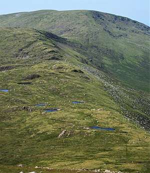
Tarfessock is a hill in the Range of the Awful Hand range in the Galloway Hills, part of the Southern Uplands of Scotland. A craggy hill, it is the lowest Donald in the range, being completely obscured by Kirriereoch Hill when viewed from the Merrick. A nearby south top is dotted with a series of lochans. A farmhouse of the same name is located to the west,[2] which along with the hill was at one time the property of the Marquess of Ailsa.[3]
| Tarfessock | |
|---|---|
 | |
| Highest point | |
| Elevation | 694.2 m (2,278 ft) [1] |
| Coordinates | 55.17139816,-4.49950654 |
| Geography | |
| Location | South Ayrshire, Scotland |
| Parent range | Range of the Awful Hand, Galloway Hills, Southern Uplands |
| OS grid | NX 40906 89186 |
| Topo map | OS Landranger 77 |
Subsidiary SMC Summits
| Summit | Height (m) | Listing[4] |
|---|---|---|
| Tarfessock South Top | 620 | DT,sSim[5] |
gollark: I mean, yes, they're not the same thing, but overlap.
gollark: I'm not sure if we need CS *and* programming.
gollark: You cannot """""merge channels", this is impossible.
gollark: Where did they get "C evaluates code right to left" from?
gollark: It vanishes a bit when loading the newly rotated icon I think.
References
- "Tarfessock, South Ayrshire (DG8 6TA)". OS GetOutside. Retrieved 2020-04-11.
- Ayrshire, Sheet LXIII (includes: Barr; Minnigaff) (Map). Ordnance Survey. 1858.
- Ayrshire Ordnance Survey Name Book. 9. Ordnance Survey. pp. 51, 55. OS1/3/9/51 – via ScotlandsPlaces.
- http://www.hills-database.co.uk/database_notes.html#classification
- https://www.hill-bagging.co.uk/mountaindetails.php?qu=S&rf=1711
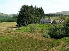
Tarfessock farm house
This article is issued from Wikipedia. The text is licensed under Creative Commons - Attribution - Sharealike. Additional terms may apply for the media files.