Szczytno County
Szczytno County (Polish: powiat szczycieński) is a unit of territorial administration and local government (powiat) in Warmian-Masurian Voivodeship, northern Poland. It came into being on January 1, 1999, as a result of the Polish local government reforms passed in 1998. Its administrative seat and largest town is Szczytno, which lies 45 kilometres (28 mi) south-east of the regional capital Olsztyn. The only other town in the county is Pasym, lying 18 km (11 mi) north-west of Szczytno.[1]
Szczytno County Powiat szczycieński | |
|---|---|
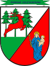
 Flag  Coat of arms | |
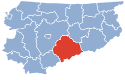
 Location within the voivodeship | |
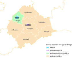
 Division into gminas | |
| Coordinates (Szczytno): 53°33′46″N 20°59′7″E | |
| Country | |
| Voivodeship | Warmian-Masurian |
| Seat | Szczytno |
| Gminas | |
| Area | |
| • Total | 1,933.1 km2 (746.4 sq mi) |
| Population (2006) | |
| • Total | 69,289 |
| • Density | 36/km2 (93/sq mi) |
| • Urban | 28,230 |
| • Rural | 41,059 |
| Car plates | NSZ |
| Website | http://www.powiat.szczytno.pl |
The county covers an area of 1,933.1 square kilometres (746.4 sq mi).[2] As of 2006 its total population is 69,289, out of which the population of Szczytno is 25,680, that of Pasym is 2,550, and the rural population is 41,059.[3]
Neighbouring counties
Szczytno County is bordered by Mrągowo County to the north, Pisz County to the east, Ostrołęka County to the south-east, Przasnysz County to the south, Nidzica County to the west and Olsztyn County to the north-west.
Administrative division
The county is subdivided into eight gminas (one urban, one urban-rural and six rural). These are listed in the following table, in descending order of population.
| Gmina | Type | Area (km²) |
Population (2006) |
Seat |
| Szczytno | urban | 10.0 | 25,680 | |
| Gmina Szczytno | rural | 347.3 | 10,454 | Szczytno * |
| Gmina Dźwierzuty | rural | 263.4 | 6,631 | Dźwierzuty |
| Gmina Wielbark | rural | 347.9 | 6,257 | Wielbark |
| Gmina Świętajno | rural | 279.8 | 5,879 | Świętajno |
| Gmina Rozogi | rural | 224.0 | 5,643 | Rozogi |
| Gmina Pasym | urban-rural | 149.4 | 5,184 | Pasym |
| Gmina Jedwabno | rural | 311.5 | 3,561 | Jedwabno |
| * seat not part of the gmina | ||||
Historical population
In 1825 Szczytno County (Kreis Ortelsburg) had 38028 inhabitants, including by mother tongue: 34928 (~92%) Polish and 3100 (~8%) German.[4][5][6]
References
- Odległości między miastami (Distances between towns)
- GIOS (Chief Inspectorate for Environmental Protection) Archived 2007-12-11 at the Wayback Machine
- Polish official population figures 2006
- von Haxthausen, August (1839). Die ländliche verfassung in den einzelnen provinzen der Preussischen Monarchie (in German). Königsberg: Gebrüder Borntraeger Verlagsbuchhandlung. pp. 78–81.
- Belzyt, Leszek (1996). "Zur Frage des nationalen Bewußtseins der Masuren im 19. und 20. Jahrhundert (auf der Basis statistischer Angaben)". Zeitschrift für Ostmitteleuropa-Forschung (in German). Bd. 45, Nr. 1: 35–71 – via zfo-online.
- Jasiński, Grzegorz (2009). "Statystyki językowe powiatów mazurskich z pierwszej połowy XIX wieku (do 1862 roku)" (PDF). Komunikaty Mazursko-Warmińskie (in Polish). 1: 97–130 – via BazHum.
