Sturgeon Bay
Sturgeon Bay is an arm of Green Bay extending southeastward approximately 10 miles into the Door Peninsula at the city of Sturgeon Bay, located approximately halfway up the Door Peninsula.[1] The bay is connected to Lake Michigan by the Sturgeon Bay Ship Canal. Three bridges cross the bay, including the historic Sturgeon Bay Bridge, and the recently finished Oregon Street Bridge.
| Sturgeon Bay | |
|---|---|
 Sturgeon Bay  Sturgeon Bay | |
| Location | Door County, Wisconsin |
| Coordinates | 44°51′15″N 87°23′40″W |
| Type | Bay |
| Surface elevation | 581 feet (177 m) |
| Settlements | Sturgeon Bay, Nasewaupee, Sevastopol, Idlewild |
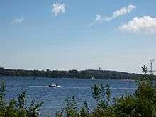
Looking southeast across Sturgeon Bay
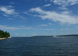
Looking northeast at the mouth of Sturgeon Bay
Climate
| ||||||||||||||||||||||||||||||||||||||||||||||||||||||||||||||||||||||||||||||||||||||||||||||||||||||||||||||||||||||||||||
Notes
- "Sturgeon Bay (Wisconsin)". Geographic Names Information System. United States Geological Survey.
- "NASA Earth Observations Data Set Index". NASA. Retrieved 30 January 2016.
gollark: FEAR.
gollark: They might not be capable of that.
gollark: They get issued the same ones by the school.
gollark: Their computers *can* compile Rust, I think.
gollark: None will be spared.
This article is issued from Wikipedia. The text is licensed under Creative Commons - Attribution - Sharealike. Additional terms may apply for the media files.