Stramproy
Stramproy is a village in the Dutch province of Limburg. It is located in the municipality of Weert.
Stramproy Rooj (Limburgish) | |
|---|---|
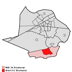 Location in the municipality Weert | |
| Coordinates: 51°11′36″N 5°43′9″E | |
| Country | Netherlands |
| Province | |
| Municipality | |
| Population (04-10-2019) | 5,160[1] |
| Dialling code | 0495 |
| Major roads | N292 |

Stramproy, church
Stramproy was a separate municipality until 1998, when it was merged with Weert.[2]
Location
Stramproy lies near the Dutch/Belgian border, about five kilometers south of the city limits of Weert. The provincial road N292 runs through the village in a north-south direction and connects to the Belgian N762 at the border, which leads to the city of Maaseik. To the north, between Stramproy and Weert, lies the smaller village of Tungelroy.
gollark: So you won't mind if I orbital-laser-strike you for no reason.
gollark: That might very well kill the prions, but unfortunately it will also kill whoever they happen to be in.
gollark: The answer is 3, of course.
gollark: Other body parts have protein in them too though.
gollark: They seem to mostly affect the brain for whatever reason.
References
- Maandcijfers per gemeente en overige regionale indelingen, 4 oktober 2019, Centraal Bureau voor de Statistiek, Voorburg/Heerlen
- Ad van der Meer and Onno Boonstra, Repertorium van Nederlandse gemeenten, KNAW, 2011.
External links
- J. Kuyper, Gemeente Atlas van Nederland, 1865-1870, "Stramproy". Map of the former municipality, around 1868.
This article is issued from Wikipedia. The text is licensed under Creative Commons - Attribution - Sharealike. Additional terms may apply for the media files.