Stevrek Ridge
Stevrek Ridge (Bulgarian: хребет Стеврек, ‘Hrebet Stevrek’ \'hre-bet 'stev-rek\) is the narrow rocky ridge extending 29.9 km from the southwest part of Arkovna Ridge to the west to Radovene Point to the east, 4.1 km wide, and rising to 1300 m (Rilets Peak) in northern Aristotle Mountains on Oscar II Coast in Graham Land. It surmounts Mapple Glacier to the north, Sexaginta Prista Bay and Domlyan Bay to the east, and Melville Glacier to the south. The feature is named after the settlement of Stevrek in Northeastern Bulgaria.
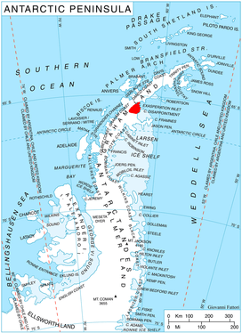
Location of Aristotle Mountains on the Antarctic Peninsula.
Location
Stevrek Ridge is centred at 65°26′35″S 62°25′00″W. British mapping in 1976.
Maps
- British Antarctic Territory. Scale 1:200000 topographic map. DOS 610 Series, Sheet W 65 62. Directorate of Overseas Surveys, Tolworth, UK, 1976.
- Antarctic Digital Database (ADD). Scale 1:250000 topographic map of Antarctica. Scientific Committee on Antarctic Research (SCAR), 1993–2016.
gollark: Things can in fact break without being engines.
gollark: Spherical wheels WHEN?
gollark: I *sort of* like it.
gollark: Were you likely to escape battery explosions with non-bulletproof glass?
gollark: There are non-tesla electric vehicle companies at least.
References
- Stevrek Ridge. SCAR Composite Antarctic Gazetteer.
- Bulgarian Antarctic Gazetteer. Antarctic Place-names Commission. (details in Bulgarian, basic data in English)
External links
- Stevrek Ridge. Copernix satellite image
This article includes information from the Antarctic Place-names Commission of Bulgaria which is used with permission.
This article is issued from Wikipedia. The text is licensed under Creative Commons - Attribution - Sharealike. Additional terms may apply for the media files.