Stevenson Dam Bridge
The Stevenson Dam Bridge carries Connecticut Route 34 over the Housatonic River in the U.S. state of Connecticut, connecting the town of Monroe to the town of Oxford.
Stevenson Dam Bridge | |
|---|---|
 | |
| Coordinates | 41°23′00″N 73°10′17″W |
| Carries | 2 lanes of |
| Crosses | Housatonic River |
| Locale | Monroe and Oxford (Connecticut) |
| Official name | Stevenson Dam Bridge |
| Maintained by | Connecticut Department of Transportation[1] (Owned by the Connecticut Light and Power Company) |
| ID number | 1843 |
| Characteristics | |
| Design | concrete arch |
| Total length | 1213 ft |
| Width | 42 ft |
| History | |
| Opened | 1919 |
| Statistics | |
| Toll | None |
| |
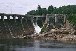
The Stevenson Dam Bridge sits on top of the Stevenson Dam, constructed by the Connecticut Light and Power Company. It is a concrete span featuring 24 arches.[2] The current bridge was constructed in 1919 and is 1213 feet in length by 42 feet in width, featuring one lane in each direction for automotive traffic.
Historical Information
A prior, one lane wooden suspension bridge known as "Zoar Bridge" existed just south of the confluence of the Halfway River with the Housatonic, at what is now the Monroe/Newtown town line, about 3/4 mile upstream from the dam/bridge current location. The supports for the old bridge were inundated with the construction of the dam. This bridge was not the predecessor to the current Derby-Shelton Bridge.[3]
Renovations
Notes
- "Department of Transportation". Connecticut Department of Transportation.
- http://environment.transportation.org/pdf/HistoricBridgePreservationPlan.pdf
- "The View From/Stevenson Dam; How to Fix or Replace an Aging Bridge Over the Housatonic?". The New York Times. 29 March 1998.
- "1959-Main".
- Holtz, Jeff (10 April 2005). "IN BRIEF; Weekend Closings Set For Stevenson Dam Bridge" – via NYTimes.com.
- http://www.housegop.state.ct.us/pressrel/Hovey/2005/press112n.htm
Crossings of the Housatonic River | ||||
|---|---|---|---|---|
| ||||