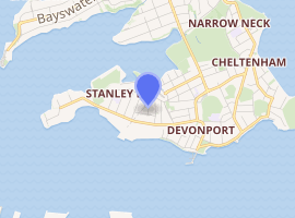
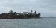
Stanley Bay, New Zealand
Stanley Bay on the North Shore, New Zealand is a small suburb near Devonport, Auckland. It is mostly residential. The Devonport Naval Base lies to the east of the bay on the south side of the Stanley Bay peninsula and is connected to storage facilities on the north side at Ngataringa Bay by a tunnel.[1]
Stanley Bay | |
|---|---|
Suburb | |
| |
| Country | New Zealand |
| Local authority | Auckland Council |
| Electoral ward | North Shore Ward |
| Population (2018) | |
| • Total | 2,025 |
| (Shoal Bay) | (Ngataringa Bay) | (Ngataringa Bay) |
| (Waitematā Harbour) |
|
Devonport |
| (Waitematā Harbour) | (Waitematā Harbour) | (Waitematā Harbour) |
Name
The area is named after Owen Stanley, captain of HMS Britomart (1808),[2] who conducted a survey of the Waitematā Harbour in 1841.[3]
Demographics
| Year | Pop. | ±% p.a. |
|---|---|---|
| 2006 | 2,028 | — |
| 2013 | 2,040 | +0.08% |
| 2018 | 2,025 | −0.15% |
| Source: [4] | ||
The statistical area is called Stanley Point. It had a population of 2,025 at the 2018 New Zealand census, a decrease of 15 people (-0.7%) since the 2013 census, and a decrease of 3 people (-0.1%) since the 2006 census. There were 615 households. There were 1,050 males and 975 females, giving a sex ratio of 1.08 males per female. The median age was 37.7 years, with 387 people (19.1%) aged under 15 years, 492 (24.3%) aged 15 to 29, 891 (44.0%) aged 30 to 64, and 252 (12.4%) aged 65 or older.
Ethnicities were 88.7% European/Pākehā, 7.6% Māori, 2.1% Pacific peoples, 4.0% Asian, and 5.6% other ethnicities (totals add to more than 100% since people could identify with multiple ethnicities).
The proportion of people born overseas was 31.0%, compared with 27.1% nationally.
Although some people objected to giving their religion, 58.4% had no religion, 32.1% were Christian, and 3.6% had other religions.
Of those at least 15 years old, 684 (41.8%) people had a bachelor or higher degree, and 87 (5.3%) people had no formal qualifications. The median income was $47,800. The employment status of those at least 15 was that 945 (57.7%) people were employed full-time, 237 (14.5%) were part-time, and 33 (2.0%) were unemployed.[4]
Education
Stanley Bay School is a coeducational contributing primary school (years 1–6), with a roll of 228 as of March 2020.[5][6] The school motto is "Those Who Do Their Best Do Well".[7]
Notes
- Gregory's Auckland & Surrounds Street Directory (3rd ed.). 2008. maps 66–67. ISBN 978-0-7319-2048-8.
- "(1800–1913) Owen Stanley and HMS Britomart". National Museum of the Royal New Zealand Navy. Retrieved 12 April 2019.
- "Stanley Street". Auckland Museum. Retrieved 7 February 2009.
- "Statistical area 1 dataset for 2018 Census". Statistics New Zealand. March 2020. Stanley Point (131400). 2018 Census place summary: Stanley Point
- "New Zealand Schools Directory". New Zealand Ministry of Education. Retrieved 26 April 2020.
- Education Counts: Stanley Bay School
- "Stanley Bay School". Stanley Bay School. Retrieved 12 April 2019.
External links
- Stanley Bay School
- Chaos In The CBD - 78 To Stanley Bay
- Photographs of Stanley Bay held in Auckland Libraries' heritage collections.