St. Regis River
The St. Regis River is an 86-mile-long (138 km)[2] river in northern New York in the United States. It flows into the Saint Lawrence River at the hamlet of Saint Regis in the St. Regis Mohawk Reservation. The Saint Regis River basin includes Upper and Lower St. Regis Lakes, and Saint Regis Pond in the Saint Regis Canoe Area. It's a great fishery for trout.
| St. Regis River | |
|---|---|
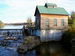 The river at St. Regis Falls | |
| Location | |
| Country | United States |
| State | New York |
| Physical characteristics | |
| Mouth | Saint Lawrence River |
• location | Saint Regis, New York, Franklin County |
• coordinates | 44°59′58.2″N 74°38′28.3″W |
• elevation | 152[1] ft (46 m) |
| Length | 86 mi (138 km) |
| Basin size | 860 sq mi (2,200 km2) |
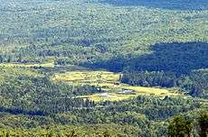
St. Regis River as seen from Azure Mountain, town of Waverly
See also
- List of rivers in New York
References
- "St Regis River". usgs.gov. usgs. 1995. Retrieved 4 May 2017.
data
- "The National Map". U.S. Geological Survey. Retrieved Feb 11, 2011.
External links
This article is issued from Wikipedia. The text is licensed under Creative Commons - Attribution - Sharealike. Additional terms may apply for the media files.