Sproat Lake
Sproat Lake is a lake on central Vancouver Island in British Columbia, Canada. It was known as Kleecoot (meaning "wide open") by local indigenous people.

| Sproat Lake | |
|---|---|
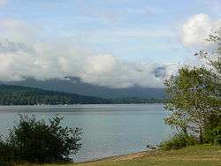 Morning at Sproat Lake Provincial Park | |
 Sproat Lake | |
| Location | Vancouver Island, British Columbia |
| Coordinates | 49°16′N 125°02′W |
| Basin countries | Canada |
| Surface area | 3,775 ha (9,330 acres) |
| Average depth | 74 m (243 ft) |
| Max. depth | 195 m (640 ft) |
| Shore length1 | 90.8 km (56.4 mi) |
| References | [1] |
| 1 Shore length is not a well-defined measure. | |
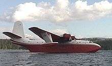
Roughly cross-shaped with four arms, it is over 25 kilometres in length, and has 90.8 kilometres of shoreline.[1] Home of the last Martin Mars type waterbombers, and near Port Alberni, Sproat Lake is a popular summer recreational area for the Alberni Valley. Highway 4 runs along its north shore.[2]
The lake maintains a small wintering population of Marbled Murrelets which also nest in the area, the only freshwater alcids on Earth.
History
Although Sproat Lake is best known for being a scenic vacation spot, it is known to most archaeologists as a site left over by Archaic people no older than 11,000 BCE. The bow and arrow reached the region sometime early in this period, between 750 and 100 (cal) BCE (Blitz 1988; Pettigrew 1990; Ross 1990). The K’ak’awin petroglyph may represent a mythical or actual sea creature from ancient times. Many believe that they were carved by ancestors of the Nootka people from British Columbia, but there is no concrete evidence pointing to them. Not much is actually known about the people who created them.
Until 1864 this lake was known by its anglicized Nootka name of Kleecoot. From then it was renamed by Robert Brown of the Vancouver Island Exploring Expedition as Sproat Lake in honour of entrepreneur and colonial official Gilbert Malcolm Sproat.[3]:252[4]
Parks
In addition to a number of lakeside residences, the lake has three provincial parks on its shores: Sproat Lake Provincial Park, Taylor Arm Provincial Park, and Fossli Provincial Park.
References
- "Vancouver Island Large Lakes Management Plan" (PDF). Fish and Wildlife Branch, Ministry of Forests, Lands and Natural Resource Operations.
- Port Alberni Tourism Retrieved December 6, 2016
- Akrigg, G.P.V.; Akrigg, Helen B. (1986), British Columbia Place Names (3rd, 1997 ed.), Vancouver: UBC Press, ISBN 0-7748-0636-2
- BC Geographical Names - Sproat Lake Retrieved December 6, 2016