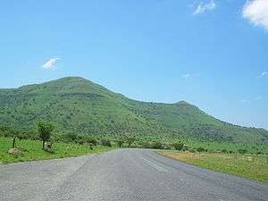
Spion Kop (mountain)
Spion Kop (Afrikaans: Spioenkop, Afrikaans pronunciation: [spiˈunkɔp]) is a mountain in the province of KwaZulu-Natal, South Africa. It is located near the town of Ladysmith, 27 km to the WSW and about 2.5 km to the north of the Spioenkop Dam, a reservoir for the waters of the Tugela River.
| Spion Kop | |
|---|---|
| Spioenkop | |
 | |
| Highest point | |
| Elevation | 1,460 m (4,790 ft) [1] |
| Listing | List of mountains in South Africa |
| Coordinates | 28°39′0″S 29°30′59″E |
| Geography | |
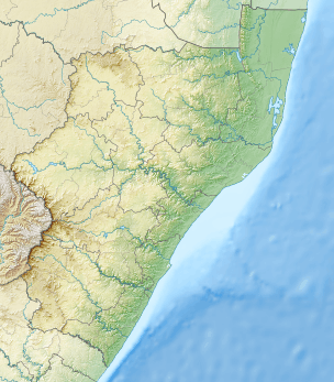 Spion Kop Location in KwaZulu-Natal | |
| Location | KwaZulu-Natal |
| Parent range | Drakensberg |
| Climbing | |
| First ascent | Unknown |
History
This mountain has historical significance. Its hilltop was the site of the Battle of Spion Kop (one of the most important battles of the Boer Wars) from 23 to 24 January 1900.[2] near the Tugela River, Natal in South Africa
Spion Kop Nature Reserve is located beneath the southern side of this mountain.[3]
gollark: Okay, Macronous encoding apioids online.
gollark: Sorry, making the encoder go fast is hard.
gollark: Hmm, actually, what codec should I use?
gollark: Okay, it's 20Mbps (!!!!!) H.264 and only 3 minutes long.
gollark: Depending on how long it is and how bee apio the macronoids decide to be.
See also
- Battle of Spion Kop
- Spion Kop Battlefield Memorials
- Spioenkop Dam
- Spion Kop (stadiums)
- SAS Spioenkop (F147) - a Valour-class frigate of the South African Navy
References
- Google Earth
- Oliver Ransford (1971). Battle Of Spion Kop. London: John Murray.
- Spion Kop Nature Reserve
This article is issued from Wikipedia. The text is licensed under Creative Commons - Attribution - Sharealike. Additional terms may apply for the media files.