South Patten River
The South Patten River is a tributary of the Patten River, flowing in Cochrane District, in Northeastern Ontario, in Canada. The “South Patten River” flows in townships of Hepburn and Adair.
| South Patten | |
|---|---|
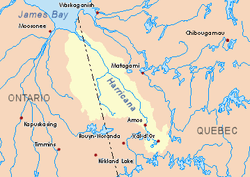
 Harricana River basin in yellow | |
| Location | |
| Country | Canada |
| Province | Ontario |
| District | Cochrane |
| Physical characteristics | |
| Source | |
| • location | Cochrane District, Ontario |
| • coordinates | 49°08′57″N 79°40′26″W |
| • elevation | 331 m (1,086 ft) |
| Mouth | Patten River |
• location | Cochrane District, Ontario |
• coordinates | 49°05′35″N 79°45′52″W |
• elevation | 290 m (950 ft) |
| Length | 19.2 km (11.9 mi)[1] |
Geography
The neighboring hydrographic slopes of the “South Patten River” are:
- North side: Patten River, Turgeon River (Ontario and Quebec);
- East side: Turgeon River (Ontario and Quebec), Boivin River (Quebec);
- South side: Chaboillez River, La Reine River (Abitibi Lake) (Quebec and Ontario);
- West side: Kabika River, East Kabika River, Case River.
The main source of the “South Patten River” is a creek (elevation: 331 metres (1,086 ft)). This source is located at:
- 18.1 kilometres (11.2 mi) West of Ontario - Quebec border;
- 20.9 kilometres (13.0 mi) North of the mouth of “South Patten River”;
- 19.4 kilometres (12.1 mi) North of the North-West Bay of Abitibi Lake.
From it source, the “South Patten River” flows on 19.2 kilometres (11.9 mi), on these segments:
- 3.0 kilometres (1.9 mi) to South-East, up to a creek (coming from South);
- 6.1 kilometres (3.8 mi) to North, then Nord-East, passing on the North-West side of a mountain (summit of 397 metres (1,302 ft)), up to a creek (coming from South);
- 10.1 kilometres (6.3 mi) to the North, snaking up to the mouth of the river.[2]
The mouth of the Patten River empties on the West shore of Patten River. This mouth of the river is located in forest area at:
- 11.5 kilometres (7.1 mi) west of Ontario - Quebec border;
- 35.8 kilometres (22.2 mi) south of the mouth of the Patten River;
- 109.4 kilometres (68.0 mi) southwest of the mouth of Turgeon River (confluence with Harricana River;
- 28.4 kilometres (17.6 mi) North of the North-West Bay of Abitibi Lake.
Toponymy
The term "Patten" refers to a family name of English origin.
gollark: The fact that login does require some signup in advance for the return URL and all that?
gollark: Slightly more precise time-of-death?
gollark: Well, explain and *I* might join in if you have a good explanation.
gollark: <@!186900186025558017>
gollark: (even ignoring the fact that the login stuff could just require a key but not the rest)
See also
- Little Clive River, a watercouse
- Patten River, a watercouse
- Turgeon River, a watercouse
- Harricana River, a watercouse
- James Bay
- Cochrane District (Ontario)
- List of rivers of Ontario
References
- Atlas of Canada
- Distances measured from the Atlas of Canada (published on Internet) of the Department of Natural Resources Canada.
External links
This article is issued from Wikipedia. The text is licensed under Creative Commons - Attribution - Sharealike. Additional terms may apply for the media files.