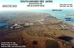
South Naknek Airport
South Naknek Airport (IATA: WSN, ICAO: PFWS, FAA LID: WSN), also known as South Naknek Nr 2 Airport, is a state-owned public-use airport located one nautical mile (1.85 km) southwest of the central business district of South Naknek, in the Bristol Bay Borough of the U.S. state of Alaska.[1]
South Naknek Airport South Naknek Nr 2 Airport | |||||||||||||||
|---|---|---|---|---|---|---|---|---|---|---|---|---|---|---|---|
 | |||||||||||||||
| Summary | |||||||||||||||
| Airport type | Public | ||||||||||||||
| Owner | State of Alaska DOT&PF - Central Region | ||||||||||||||
| Serves | South Naknek, Alaska | ||||||||||||||
| Elevation AMSL | 162 ft / 49 m | ||||||||||||||
| Coordinates | 58°42′08″N 157°00′09″W | ||||||||||||||
| Runways | |||||||||||||||
| |||||||||||||||
| Statistics (2008) | |||||||||||||||
| |||||||||||||||
As per Federal Aviation Administration records, this airport had 330 commercial passenger boardings (enplanements) in calendar year 2008, a decrease of 19% from the 409 enplanements in 2007.[2] South Naknek Airport is included in the FAA's National Plan of Integrated Airport Systems (2009-2013), which categorizes it as a general aviation facility.[3]
Facilities and aircraft
South Naknek Airport covers an area of 214 acres (87 ha) at an elevation of 162 feet (49 m) above mean sea level. It has two runways: 4/22 is 2,264 by 60 feet (690 x 18 m) with a gravel surface; 12/30 is 3,314 by 60 feet (1,010 x 18 m) with a gravel and dirt surface.[1]
For the 12-month period ending December 31, 2008, the airport had 3,530 aircraft operations, an average of 294 per month: 94% air taxi and 6% general aviation.[1]
References
- FAA Airport Master Record for WSN (Form 5010 PDF). Federal Aviation Administration. effective 27 Aug 2009.
- CY 2008 Passenger Boarding and All-Cargo Data (Preliminary). Federal Aviation Administration. Published 15 July 2009.
- FAA National Plan of Integrated Airport Systems: 2009-2013. Federal Aviation Administration. Published 1 Oct 2008.
External links
- Airport diagram for South Naknek NR 2 (WSN) (GIF). FAA, Alaska Region. 5 Aug 2004.
- Resources for this airport:
- FAA airport information for WSN
- AirNav airport information for WSN
- ASN accident history for WSN
- FlightAware airport information and live flight tracker
- SkyVector aeronautical chart for WSN