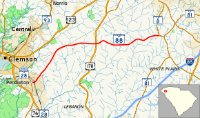
South Carolina Highway 88
South Carolina Highway 88 (SC 88) is a 14.5-mile (23.3 km) state highway in northern Anderson County, South Carolina with a brief entry into southern Pickens County, connecting Pendleton and areas south of Powdersville. It is sometimes considered an alternate route for U.S. Highway 123 (US 123).
| ||||
|---|---|---|---|---|
 | ||||
| Route information | ||||
| Maintained by SCDOT | ||||
| Length | 14.50 mi[1] (23.34 km) | |||
| Existed | 1960s–present | |||
| Major junctions | ||||
| West end | ||||
| East end | ||||
| Location | ||||
| Counties | Anderson, Pickens | |||
| Highway system | ||||
| ||||
Route description
The route travels generally in a west–east direction, beginning at an intersection with SC 28 Business (SC 28 Bus.) in downtown Pendleton. East of Pendleton, SC 88 travels through somewhat rural areas and has a flashing stop light intersection with US 178. The route continues until it terminates at an intersection with SC 8, west of the suburban areas of Powdersville.[2][3]
History
Junction list
| County | Location | mi[1] | km | Destinations | Notes | |||
|---|---|---|---|---|---|---|---|---|
| Anderson | Pendleton | 0.00 | 0.00 | |||||
| Pickens |
No major junctions | |||||||
| Anderson | | 8.02 | 12.91 | |||||
| | 14.50 | 23.34 | ||||||
| 1.000 mi = 1.609 km; 1.000 km = 0.621 mi | ||||||||
gollark: I don't think you can reasonably just blame landlords. Housing prices are a complex problem.
gollark: I would hope not.
gollark: There really should be a "ping online members of role" function.
gollark: As far as I'm aware the many worlds thing is just one interpretation of... quantum things.
gollark: As far as I'm aware, and my knowledge of this is very minimal, physics just gives you a probability distribution of what might happen in a quantum thing and there are a bunch of interpretations of how that actually translates into reality.
References
- South Carolina Department of Transportation: Statewide Highways 2012. Specifics: . Files: .
- General Highway System - Anderson County, South Carolina (PDF) (Map). South Carolina Department of Transportation. August 2005. Retrieved September 7, 2013.
- General Highway System - Pickens County, South Carolina (PDF) (Map). South Carolina Department of Transportation. August 2005. Retrieved September 7, 2013.
External links

This article is issued from Wikipedia. The text is licensed under Creative Commons - Attribution - Sharealike. Additional terms may apply for the media files.
