South Carolina Highway 7
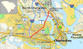
South Carolina Highway 7 (SC 7) is a 5.92-mile-long (9.53 km) state highway in the east-central part of the U.S. state of South Carolina. The route connects the West Ashley part of the city of Charleston with North Charleston.
| ||||
|---|---|---|---|---|
 | ||||
| Route information | ||||
| Maintained by SCDOT | ||||
| Length | 5.92 mi[1] (9.53 km) | |||
| Existed | 1956–present | |||
| Major junctions | ||||
| South end | ||||
| ||||
| North end | ||||
| Location | ||||
| Counties | Charleston | |||
| Highway system | ||||
| ||||

Route description
SC 7 begins at an intersection with U.S. Route 17 (US 17; Savannah Highway) in West Ashley. Here, it also has an interchange with Interstate 526 (I-526). It heads east-northeast to an intersection with SC 61. A little while later, it meets the northern terminus of SC 171. Then, the highway crosses over the Ashley River. On the east side of the river, SC 7 enters North Charleston. Almost immediately is an interchange with I-26. About one mile (1.6 km) later, it meets its northern terminus, an intersection with US 52/US 78 (Rivers Avenue).[2]
Major intersections
The entire route is in Charleston County.
| Location | mi[1] | km | Destinations | Notes | |
|---|---|---|---|---|---|
| Charleston | 0.00 | 0.00 | Southern terminus | ||
| 0.11 | 0.18 | I-526 exit 10; no access to eastbound I-526 from northbound SC 7 | |||
| 1.29 | 2.08 | ||||
| 3.08 | 4.96 | Northern terminus of SC 171 | |||
| North Charleston | 4.99 | 8.03 | I-26 exits 216 A–B | ||
| 5.92 | 9.53 | Northern terminus; Cosgrove Avenue continues past. | |||
| 1.000 mi = 1.609 km; 1.000 km = 0.621 mi | |||||
See also


References
- South Carolina Department of Transportation: Statewide Highways 2012. Specifics: . Files: .
- Google (February 4, 2018). "South Carolina Highway 7" (Map). Google Maps. Google. Retrieved February 4, 2018.
External links

- SC 7 - South Carolina Hwy Index