South Carolina Highway 329
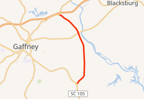
South Carolina Highway 329 (SC 329) is a primary state highway in the U.S. state of South Carolina. It serves as an eastern bypass to the town of Gaffney.
| ||||
|---|---|---|---|---|
| Victory Trail Road | ||||
| ||||
| Route information | ||||
| Maintained by SCDOT | ||||
| Length | 6.3 mi[1] (10.1 km) | |||
| Existed | 1982–present | |||
| Major junctions | ||||
| South end | ||||
| North end | ||||
| Location | ||||
| Counties | Cherokee | |||
| Highway system | ||||
| ||||

Route description
SC 329 is a two-lane bypass route between SC 105 and SC 18, located east of Gaffney. It is also known as the Victory Trail Road, as it overlaps with the Overmountain Victory National Historic Trail.[2]
History
SC 329 was established by 1982 as a new primary route between SC 105 and SC 18.[3]
The first SC 329 was established in 1942 as a new primary routing between SC 22 in Glymphville and SC 177. In 1948, it was decommissioned and downgraded to secondary roads S-36-28 and S-40-32.
South Carolina Highway 180
| |
|---|---|
| Location | Gaffney, South Carolina |
| Length | 2.2 mi[4] (3.5 km) |
| Existed | 1942–1948 |
South Carolina Highway 180 (SC 180) was established as a new primary routing between U.S. Route 29 (US 29) and SC 18 northeast of Gaffney. In 1948, it was decommissioned and downgraded to secondary road S-11-32.[5] Around 1982, most of the former route became part of SC 329.
Junction list
The entire route is in Cherokee County.
| Location | mi[1] | km | Destinations | Notes | |
|---|---|---|---|---|---|
| | 0.0 | 0.0 | |||
| | 4.2 | 6.8 | |||
| | 6.3 | 10.1 | |||
| 1.000 mi = 1.609 km; 1.000 km = 0.621 mi | |||||
References
- Google (August 22, 2015). "South Carolina Highway 329" (Map). Google Maps. Google. Retrieved August 22, 2015.
- General Highway System, Cherokee County (PDF) (Map). South Carolina Department of Transportation. June 2005. Retrieved August 22, 2015.
- General Highway Map, Cherokee County, South Carolina (PDF) (Map). Cartography by SCDOT. South Carolina Department of Transportation. 1986. Retrieved August 22, 2015.
- Google (August 22, 2015). "South Carolina Highway 180" (Map). Google Maps. Google. Retrieved August 22, 2015.
- General Highway Map, Cherokee County, South Carolina (PDF) (Map). Cartography by SCDOT. South Carolina Department of Transportation. 1943. Retrieved August 22, 2015.
External links

- Mapmikey's South Carolina Highways Page: SC 320-329