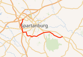
South Carolina Highway 295
South Carolina Highway 295 (SC 295) is a state highway connecting the Spartanburg County, South Carolina communities of Pacolet and Una.
| ||||
|---|---|---|---|---|
| ||||
| Route information | ||||
| Maintained by SCDOT | ||||
| Length | 16.67 mi[1] (26.83 km) | |||
| Existed | 1940–present | |||
| Major junctions | ||||
| South end | ||||
| North end | ||||
| Location | ||||
| Counties | Spartanburg | |||
| Highway system | ||||
| ||||

Route description
History
Major intersections
The entire route is in Spartanburg County.
| Location | mi[1] | km | Destinations | Notes | |
|---|---|---|---|---|---|
| | 0.00 | 0.00 | |||
| Spartanburg | 5.70 | 9.17 | |||
| | 9.45– 9.58 | 15.21– 15.42 | Interchange | ||
| Spartanburg | 11.69 | 18.81 | Southern end of SC 296 concurrency | ||
| 12.59 | 20.26 | Northern terminus of SC 215; northern end of SC 296 concurrency | |||
| 13.59 | 21.87 | ||||
| Arcadia–Saxon line | 16.67 | 26.83 | Exit 3 (I-85 Bus.); access to I-85 Bus. via Simuel Road / New Cut Road | ||
1.000 mi = 1.609 km; 1.000 km = 0.621 mi
| |||||
gollark: Cookie Dragons!
gollark: Potato Wyverns!
gollark: [*OTHER FOOD*] dragons!
gollark: We need [*NOBLE GAS*] Amphipteres!
gollark: Neon Ampipthetre or whatever?
References
- "Statewide Highways (shapefile)" (zip). South Carolina Department of Transportation. September 29, 2017. Retrieved December 8, 2017.
External links

- SC 295 South Carolina Hwy Index
This article is issued from Wikipedia. The text is licensed under Creative Commons - Attribution - Sharealike. Additional terms may apply for the media files.