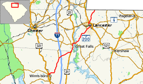
South Carolina Highway 200
South Carolina Highway 200 (SC 200) is a primary state highway in the U.S. state of South Carolina. It connects the cities of Winnsboro, Great Falls, and Lancaster.
| ||||
|---|---|---|---|---|
 | ||||
| Route information | ||||
| Maintained by SCDOT | ||||
| Length | 41.7 mi[1] (67.1 km) | |||
| Existed | 1937–present | |||
| Major junctions | ||||
| West end | ||||
| ||||
| East end | ||||
| Location | ||||
| Counties | Fairfield, Chester, Lancaster | |||
| Highway system | ||||
| ||||
Route description
SC 200 in Fairfield County
SC 200 is mostly a rural two-lane highway, traversing northwest from Winnsboro, through Great Falls and Lancaster, to the North Carolina state line.
History
Established in 1937 as a renumbering part of SC 93 to match NC 200; it originally traversed 7 miles (11 km) from US 521 to the North Carolina state line. By 1952, SC 200 was extended to its current southern terminus in Winnsboro; this replaced SC 93 from Lancaster to Great Falls and SC 22 from Great Falls to Winnsboro.[2]
Junction list
| County | Location | mi[1] | km | Destinations | Notes |
|---|---|---|---|---|---|
| Fairfield | Winnsboro | 0.0 | 0.0 | ||
| 0.7 | 1.1 | ||||
| | 10.6 | 17.1 | |||
| | 11.6 | 18.7 | |||
| | 17.0 | 27.4 | South end of US 21 overlap | ||
| Chester | Great Falls | 20.0 | 32.2 | ||
| 21.2 | 34.1 | North end of SC 97 overlap | |||
| 21.4 | 34.4 | North end of US 21 overlap | |||
| Lancaster | | 21.8 | 35.1 | South end of SC 97 overlap | |
| Lancaster | 31.1 | 50.1 | |||
| 32.8 | 52.8 | South end of US 521 Business overlap | |||
| 33.5 | 53.9 | ||||
| 33.9 | 54.6 | ||||
| 34.8 | 56.0 | North end of US 521 Business overlap | |||
| | 41.7 | 67.1 | Continuation beyond North Carolina state line | ||
1.000 mi = 1.609 km; 1.000 km = 0.621 mi
| |||||
gollark: None can escape.
gollark: If you liked the quartic formula you would love the quintic formula, except there is no such thing and provably cannot be.
gollark: As you can see, the quartic formula is 333333333333333333333 practical.
gollark: Okay, fixed.
gollark: Oh, backgrounds.
References
- Google (November 24, 2012). "South Carolina Highway 200" (Map). Google Maps. Google. Retrieved November 24, 2012.
- "Mapmikey's South Carolina Highways Page (SC 200-209)". Retrieved November 24, 2012.
External links

- SC 200 South Carolina Hwy Index
This article is issued from Wikipedia. The text is licensed under Creative Commons - Attribution - Sharealike. Additional terms may apply for the media files.
