South Carolina Highway 194
South Carolina Highway 194 (SC 194) is a 14.7-mile-long (23.7 km) state highway in the U.S. state of South Carolina. The highway connects Saluda and rural areas of Saluda County.
| ||||
|---|---|---|---|---|
 | ||||
| Route information | ||||
| Maintained by SCDOT | ||||
| Length | 14.69 mi[1] (23.64 km) | |||
| Major junctions | ||||
| South end | ||||
| North end | ||||
| Location | ||||
| Counties | Saluda | |||
| Highway system | ||||
| ||||

Route description
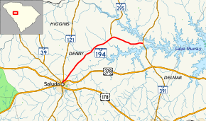
SC 194 begins at an intersection with U.S. Route 378 (US 378; North Jennings Street and Travis Avenue) in Saluda, within Saluda County. It travels to the north and almost immediately curves to the northeast before leaving the city limits. The highway crosses over Burnets Creek and Big Creek. Farther to the northeast is a crossing of Indian Creek, just before an intersection with SC 395 (Kempson Bridge Road). The highway then curves to the southeast and goes in an easterly direction to meet its eastern terminus, an intersection with SC 391 (Prosperity Highway), at a point south of Stoney Hill.[2]
Major intersections
The entire route is in Saluda County.
| Location | mi[1] | km | Destinations | Notes | |
|---|---|---|---|---|---|
| Saluda | 0.00 | 0.00 | |||
| | 10.09 | 16.24 | Southern terminus of SC 395 | ||
| | 14.69 | 23.64 | |||
| 1.000 mi = 1.609 km; 1.000 km = 0.621 mi | |||||
See also


References
- "Statewide Highways (shapefile)" (zip). South Carolina Department of Transportation. September 29, 2017. Retrieved December 8, 2017.
- Google (May 10, 2016). "South Carolina Highway 194" (Map). Google Maps. Google. Retrieved May 10, 2016.
External links

- SC 194 South Carolina Hwy Index