South Carolina Highway 153
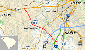
South Carolina Highway 153 (SC 153) is a 7.1-mile (11.4 km) state highway, providing a major connection between U.S. Highway 123 and Interstate 85 and serving as a primary commercial corridor for the suburban Greenville community of Powdersville.
| ||||
|---|---|---|---|---|
 | ||||
| Route information | ||||
| Maintained by SCDOT | ||||
| Length | 7.11 mi[1] (11.44 km) | |||
| Existed | 1960s–present | |||
| Major junctions | ||||
| South end | Brown Road near Powdersville | |||
| North end | ||||
| Location | ||||
| Counties | Greenville, Anderson, Pickens | |||
| Highway system | ||||
| ||||

Route description
The route travels generally in a southeast to northwest direction, starting unsigned on Brown Road in western Greenville County. The highway almost immediately comes to an interchange with Southern Connector Toll Road (Interstate 185 or I-185). The two-lane road crosses over the Saluda River into Anderson County where it then meets I-85 at exit 40. From I-85 until the terminus with U.S. Highway 123 (US 123) in Pickens County, SC 153 is a four-lane road that is relatively developed with commercial land uses.[2]
Junction list
| County | Location | mi[1] | km | Destinations | Notes |
|---|---|---|---|---|---|
| Greenville | | 0.00 | 0.00 | Brown Road | |
| | 0.41 | 0.66 | Exit 12 (I-185) | ||
| Anderson | | 1.53 | 2.46 | Exit 40 (I-85) | |
| Powdersville | 2.95 | 4.75 | |||
| Pickens | | 7.11 | 11.44 | Interchange | |
| 1.000 mi = 1.609 km; 1.000 km = 0.621 mi | |||||
References
- South Carolina Department of Transportation: Statewide Highways 2012. Specifics: . Files: .
- Google (September 10, 2013). "South Carolina Highway 153" (Map). Google Maps. Google. Retrieved September 10, 2013.
External links
| Wikimedia Commons has media related to South Carolina Highway 153. |