South Carolina Highway 110
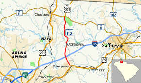
South Carolina Highway 110 (SC 110) is a state highway in the U.S. state of South Carolina that runs 9.3 miles (15.0 km) from US 29 in Cowpens to US 221 Alt and SC 11 at Cowpens National Battlefield near Chesnee.[3] It is signed[3] and internally designated[1] as an east–west highway though it runs north–south physically.
| ||||
|---|---|---|---|---|
| Battleground Road | ||||
 | ||||
| Route information | ||||
| Maintained by SCDOT | ||||
| Length | 9.28 mi[1] (14.93 km) | |||
| Existed | 1949[2]–present | |||
| Tourist routes | ||||
| Major junctions | ||||
| West end | ||||
| East end | ||||
| Location | ||||
| Counties | Cherokee, Spartanburg | |||
| Highway system | ||||
| ||||

Route description
SC 110 is a two-lane rural highway with relatively few intersections. The highway is named Battleground Road for the entire length. A section east of Mayo is also known as Cowpens Highway. The highway passes next to and ends at Cowpens National Battlefield.
History
The original SC 110 was created in 1936, running from US 221 in Chesnee north to the North Carolina border, where the road became the now-defunct NC 741. In 1942, the highway was renumbered as a part of US 221. The highway was resurrected in 1949 in its near-current form. When US 29, now I-85, was established in the mid-1950s, the highway was rerouted slightly to the west.
Junction list
| County | Location | mi[1] | km | Destinations | Notes |
|---|---|---|---|---|---|
| Cherokee | Cowpens N.B. | 0.00 | 0.00 | ||
| Spartanburg | | 7.39 | 11.89 | Exit 83 (I-85) | |
| Cowpens | 9.28 | 14.93 | |||
| 1.000 mi = 1.609 km; 1.000 km = 0.621 mi | |||||
References
- South Carolina Department of Transportation: Statewide Highways 2012. Specifics: . Files: .
- Mike Robinson (August 30, 2005). "SC 110 to 119". Angelfire. Retrieved November 25, 2012.
- Google (November 25, 2012). "South Carolina Highway 110" (Map). Google Maps. Google. Retrieved November 25, 2012.
External links

- SC 110 - South Carolina Hwy Index Home