Snake River (Nome, Alaska)
Snake River is a waterway on the Seward Peninsula in the U.S. state of Alaska. Flowing southerly, it discharges into Norton Sound, Bering Sea, at Nome, with its mouth lying between the city's downtown area and its main airport. The river is 20 miles (32 km) long.[1]
| Snake River | |
|---|---|
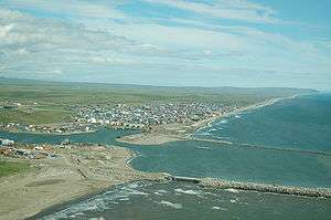 Mouth of the Snake River at Nome | |
 Location of the mouth of the Snake River in Alaska | |
| Location | |
| Country | United States |
| State | Alaska |
| District | Nome Census Area |
| Physical characteristics | |
| Source | Seward Peninsula |
| • location | Confluence of Goldbottom Creek and North Fork Snake River |
| • coordinates | 64°42′05″N 165°24′25″W[1] |
| • elevation | 193 ft (59 m)[2] |
| Mouth | Norton Sound, Bering Sea |
• location | Nome |
• coordinates | 64°29′55″N 165°24′47″W[1] |
• elevation | 13 ft (4.0 m)[1] |
| Length | 20 mi (32 km)[1] |
Gallery
.jpeg) Boats and tents at the mouth of the Snake River in Nome, ca. 1900
Boats and tents at the mouth of the Snake River in Nome, ca. 1900.jpeg) Snake River Bridge and post-storm destruction in Nome (October 1902) by Eric A. Hegg
Snake River Bridge and post-storm destruction in Nome (October 1902) by Eric A. Hegg.jpeg) A small boat navigates the Snake River in Nome September 29, 1909
A small boat navigates the Snake River in Nome September 29, 1909
gollark: Oh, wait, I already did it this time.
gollark: That would be fun for the next code guessing round.
gollark: What if you make a better macro system for C so that this works?
gollark: As planned.
gollark: https://lhartikk.github.io/jekyll/update/2017/07/12/chapter3.html
See also
References
- "Snake River". Geographic Names Information System. United States Geological Survey. March 31, 1981. Retrieved September 22, 2013.
- Derived by entering source coordinates in Google Earth.
External links
![]()
| Authority control |
|
|---|
This article is issued from Wikipedia. The text is licensed under Creative Commons - Attribution - Sharealike. Additional terms may apply for the media files.