Skin Tyee First Nation
The Skin Tyee First Nation, also known as the Skin Tyee Indian Band is a First Nations band government located in the Central Interior of British Columbia near François Lake, in the Omineca Country to the west of the City of Prince George.
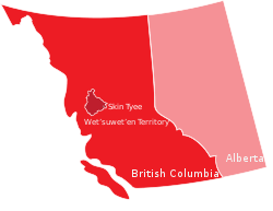
 Skin Tyee First Nation within traditional Wetʼsuwetʼen territory | |
| People | Wetʼsuwetʼen |
|---|---|
| Province | British Columbia |
| Land | |
| Main reserve | Skins Lake 16B |
| Other reserve(s) |
|
| Land area | 3.966 km2 |
| Population (2020) | |
| On reserve | 54 |
| On other land | 5 |
| Off reserve | 130 |
| Total population | 189 |
| Government | |
| Chief | Rosemarie Skin |
| Council |
|
Governance
Skin Tyee is a section 11 band that follows a custom electoral system.
Indian Reserves
Indian Reserves under the administration of the Skin Tyee First Nation are:[2]
- Skins Lake Indian Reserve No. 15, north of Skins Lake, at the head of the Cheslatta River, 183.70 ha.
- Skins Lake Indian Reserve No. 16A, 3/4 mile southeast of Octopus Lake, which is 2 miles south of Francois Lake, 64.7 ha.
- Skins Lake Indian Reserve No. 16B, on northwest shore of Uncha Lake, 64.7 ha.
- Tatla't East Indian Reserve No. 2, 56.10 ha.
- Uncha Lake Indian Reserve No. 13A, north shore of Uncha Lake, near wet end, 24.10 ha.
- Western Island Indian Reserve No. 4, a small island at the west end of Uncha Lake, 3.3 ha.
gollark: And what did you get?
gollark: What answer did you need?
gollark: It should give access to debug for fun purposes.
gollark: With no environment, but it's quite funny.
gollark: Unserialise, funnily enough, actually executes arbitrary code.
References
- "Skin Tyee". Government of Canada. Indian and Northern Affairs Canada. 2009. Retrieved July 26, 2009.
- Indian and Northern Affairs Canada Reserves/Settlements/Villages Detail Archived 2012-03-31 at the Wayback Machine
This article is issued from Wikipedia. The text is licensed under Creative Commons - Attribution - Sharealike. Additional terms may apply for the media files.