Sira (river)
Sira is a river in southwestern Norway. The 152-kilometre (94 mi) long river flows begins in the Sirdalsheiane mountains near the borders of Agder and Rogaland counties. The headwaters of the river is the lake Ytre Storevatnet and it flows south through the Sirdalen valley in the municipalities of Sirdal and Flekkefjord. The river flows through the large lakes Sirdalsvatnet and Lundevatnet before heading south on the Agder/Rogaland county border. At the village of Åna-Sira the river empties into the Åna fjord. The river runs through several large villages such as Åna-Sira, Sira, Tonstad, Lunde, and Kvæven. The river drains the 1,902.7-square-kilometre (734.6 sq mi) watershed. The Tonstad Hydroelectric Power Station is powered by water from the waterfalls along this river.[1]
| Sira | |
|---|---|
 View of the river near Tonstad | |
| Location | |
| Country | Norway |
| Counties | Agder/Rogaland |
| Municipality | Flekkefjord, Sirdal, Sokndal, Lund |
| Physical characteristics | |
| Source | Sirdalsheiane, Ytre Storevatnet |
| • location | Bykle, Agder, Norway |
| • coordinates | 59°16′35″N 06°54′40″E |
| • elevation | 1,000 m (3,300 ft) |
| Mouth | Åna |
• location | Åna-Sira, Rogaland-Agder, Norway |
• coordinates | 58°17′32″N 06°26′24″E |
• elevation | 0 m (0 ft) |
| Length | 152 km (94 mi) |
| Basin size | 1,902.7 km2 (734.6 sq mi) |
| Discharge | |
| • average | 130 m3/s (4,600 cu ft/s) |
Media gallery
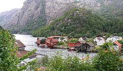 View at Åna-Sira
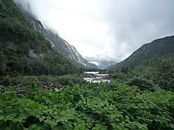
 View near Tonstad
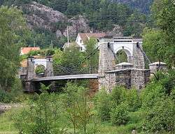 Bakke bridge over the river
See also
- List of rivers in Norway