Sidney Municipal Airport (Ohio)
Sidney City Airport (FAA LID: SCA), formerly known as Sidney Municipal Airport, is a city-owned public-use airport located three nautical miles (6 km) south of the central business district of Sidney, a city in Shelby County, Ohio, United States.[1] It is included in the National Plan of Integrated Airport Systems for 2011–2015, which categorized it as a general aviation facility.[2]
Sidney City Airport | |||||||||||||||
|---|---|---|---|---|---|---|---|---|---|---|---|---|---|---|---|
| Summary | |||||||||||||||
| Airport type | Public | ||||||||||||||
| Owner | City of Sidney | ||||||||||||||
| Serves | Sidney, Ohio | ||||||||||||||
| Elevation AMSL | 1,044 ft / 318 m | ||||||||||||||
| Coordinates | 40°14′29″N 084°09′03″W | ||||||||||||||
| Map | |||||||||||||||
 SCA Location of airport in Ohio/United States  SCA SCA (the United States) | |||||||||||||||
| Runways | |||||||||||||||
| |||||||||||||||
| Statistics (2011) | |||||||||||||||
| |||||||||||||||
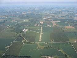
Facilities and aircraft
Sidney City Airport covers an area of 265 acres (107 ha) at an elevation of 1,044 feet (318 m) above mean sea level. It has two runways with asphalt surfaces: 10/28 is 5,013 by 75 feet (1,528 x 23 m) and 5/23 is 2,981 by 50 feet (909 x 15 m).[1]
For the 12-month period ending August 1, 2014, the airport had 20,500 aircraft operations, an average of 56 per day: 99% general aviation, 1% air taxi, and <1% military. At that time there were 37 aircraft based at this airport: 87% single-engine, 8% jet, and 5% multi-engine.[1]
References
- FAA Airport Master Record for SCA (Form 5010 PDF). Federal Aviation Administration. Effective November 15, 2012.
-
"2011–2015 NPIAS Report, Appendix A" (PDF, 2.03 MB). National Plan of Integrated Airport Systems. Federal Aviation Administration. October 4, 2010. External link in
|work=(help)
External links
- Airport page at City of Sidney website
- Aerial image as of April 1994 from USGS The National Map
- FAA Terminal Procedures for I12, effective August 13, 2020
- Resources for this airport:
- FAA airport information for SCA
- AirNav airport information for SCA
- FlightAware airport information and live flight tracker
- SkyVector aeronautical chart for SCA