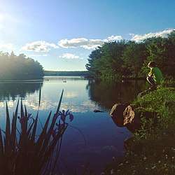
Sheldrake Lake
Sheldrake Lake is a lake in Canada.[1][2] It is located in the province of Nova Scotia, in the southeastern part of the country, 900 kilometres (560 mi) east of the capital Ottawa. Sheldrake Lake is 76 meters above sea level. The area is 0.19 square kilometers. It is located on Lake Five Island Lake. The highest point nearby is 107 meters above sea level, 1.1 km northwest of Sheldrake Lake. It stretches 0.6 kilometres (0.37 mi) in the north-south direction, and 0.5 kilometres (0.31 mi) kilometers in the east-west direction.
| Sheldrake Lake | |
|---|---|
 | |
| Location | Nova Scotia, Canada |
| Coordinates | 44.67621°N 63.79789°W |
| Type | Lake |
| Basin countries | Canada |
| Surface area | 0.19 km2 (0.073 sq mi) |
| Surface elevation | 76 m (249 ft) |
| Settlements | Halifax, Nova Scotia |
Otherwise, there are the following at Sheldrake Lake:
- Upper Sheldrake Lake
- Big Hubley Lake
In the surroundings around Sheldrake Lake, mainly forests grow. Around Sheldrake Lake, it is quite densely populated, with 108 inhabitants per square kilometer.[3] The tract is part of the hemiboreal climate zone. The annual average temperature in the funnel is 6 °C. The warmest month is July, when the average temperature is 18 °C, and the coldest is January, with -8 °C. Average yearly average is 1 826 millimeters. The rainy month is December, with an average of 299 mm rainfall, and the driest is May, with 84 mm rainfall.
References
- Observation, Government of Canada; Natural Resources Canada; Earth Sciences Sector; Canada Centre for Mapping and Earth. "Atlas of Canada 1,000,000 National Frameworks Data, Hydrology - Major River Basin". geogratis.gc.ca.
- "GeoNames.org". www.geonames.org.
- "Land Cover Classification (1 year) - NASA". Land Cover Classification (1 year) - NASA. 13 June 2017.