Shatin Pass Road
Shatin Pass Road (Chinese: 沙田坳道) is a road in the Wong Tai Sin District of Kowloon, Hong Kong, linking the Wong Tai Sin area in the south to the junction of Fei Ngo Shan Road and Jat's Incline in the north. Along the way, it passes through the Tsz Wan Shan area and Sha Tin Pass.

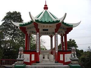
Lions Pavilion along Shatin Pass Road at Sha Tin Pass.
.jpg)
Shatin Pass Road at its junction with Tsz Wan Shan Road
.jpg)
Southern end of Shatin Pass Road, near Lung Cheung Road.
The northern part of Shatin Pass Road, between Sha Tin Pass and the junction of Fei Ngo Shan Road and Jat's Incline, is part of the Stage 4 of the Wilson Trail and Section 5 of the MacLehose Trail. This section of the road also marks the border between Sha Tin District and Wong Tai Sin District.
History
Shatin Pass Road was built by the British Army to access Sha Tin Pass and some village in Sha Tin District from Kowloon.
Features along the road
In alphabetic order:
- Chuk Yuen North Estate (竹園北邨)
- Fat Jong Temple (慈雲山法藏寺)
- Lions Pavilion at Sha Tin Pass (沙田坳獅子亭)
- Lower Wong Tai Sin Estate (黃大仙下邨)
- Muk Lun Street Playground (睦鄰街遊樂場)
- Our Lady of Maryknoll Hospital (聖母醫院)
- Our Lady's College
- Sha Tin Pass Estate (沙田坳邨)
- SKH Calvary Church (聖十架堂)
- Tsz Lok Estate (慈樂邨)
- Wong Tai Sin Police Station (黃大仙區總部及分區警署)
- Ying Fuk Court (盈福苑)
| Wikimedia Commons has media related to Shatin Pass Road. |
gollark: .goose photograph facing leftward
gollark: .goose facing leftward
gollark: Hmm, looks like your prompting actually does get it to find a more aesthetic™ image.
gollark: .goose silhouetted against the sunset
gollark: .goose technological
This article is issued from Wikipedia. The text is licensed under Creative Commons - Attribution - Sharealike. Additional terms may apply for the media files.