Shap Sze Heung
Shap Sze Heung (Chinese: 十四鄉; lit.: 'Fourteen Townships') is an area in Hong Kong located in the northern part of the Sai Kung Peninsula. Despite its proximity to the neighbouring areas administered by Sha Tin and Sai Kung districts, it is actually administered by Tai Po District.
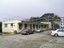
Shap Sze Heung Rural Committee Office in Kwun Hang.
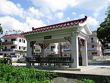
pavilion in Sai O.
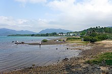
Tolo Harbour coastline in Nai Chung.
Villages
Shap Sze Heung consists of 14 villages:
- Kei Ling Ha Lo Wai (企嶺下老圍)
- Kei Ling Ha San Wai (企嶺下新圍)
- Sai Keng (西徑)
- Nga Yiu Tau (瓦窰頭) (鴨麻寮)
- Tin Liu (田寮) aka. Tai Tung Wo Liu (大洞禾寮)
- Tai Tung (大洞)
- Tseng Tau (井頭)
- Ma Kwu Lam (馬牯纜)
- Che Ha (輋下)
- Kwun Hang (官坑)
- Nai Chung (泥涌)
- Sai O (西澳)
- (將軍里)
- Cheung Muk Tau (樟木頭)
gollark: Actually no, Peak Haskell would be defining operators for all this.
gollark: This is peak haskell.
gollark: Are you *composing* pointfreely too?
gollark: As you can see, I definitely Haskell very Haskell?
gollark: I meant mapM, not mapM_.
This article is issued from Wikipedia. The text is licensed under Creative Commons - Attribution - Sharealike. Additional terms may apply for the media files.