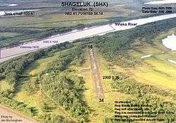
Shageluk Airport
Shageluk Airport (IATA: SHX, ICAO: PAHX, FAA LID: SHX) is a state-owned public-use airport located one nautical mile (1.85 km) north of the central business district of Shageluk, a city in the Yukon-Koyukuk Census Area of the U.S. state of Alaska.[1]
Shageluk Airport | |||||||||||||||
|---|---|---|---|---|---|---|---|---|---|---|---|---|---|---|---|
 | |||||||||||||||
| Summary | |||||||||||||||
| Airport type | Public | ||||||||||||||
| Owner | Alaska DOT&PF - Northern Region | ||||||||||||||
| Serves | Shageluk, Alaska | ||||||||||||||
| Elevation AMSL | 79 ft / 24 m | ||||||||||||||
| Coordinates | 62°41′32″N 159°34′09″W | ||||||||||||||
| Runways | |||||||||||||||
| |||||||||||||||
Facilities
Shageluk Airport covers an area of 148 acres (60 ha) at an elevation of 79 feet (24 m) above mean sea level. It has one runway designated 16/34 with a gravel surface measuring 3,400 by 50 feet (1,036 x 15 m) (expanded from the prior size of 2,200 by 35 feet). It also has a seaplane landing area on the Innoko River designated 18W/36W which measures 5,000 by 1,000 feet.[1]
Airlines
gollark: "Command"?
gollark: What?
gollark: Just stick it in rednet.open! Repeated spam won't help!
gollark: It's not hard!
gollark: Look, the idea is, you just stick a warning *into each function you want to trigger a warning in*!
References
- FAA Airport Master Record for SHX (Form 5010 PDF), effective 2009-05-07.
External links
- FAA Alaska airport diagram (GIF)
- FAA Terminal Procedures for SHX, effective August 13, 2020
- Resources for this airport:
- FAA airport information for SHX
- AirNav airport information for PAHX
- ASN accident history for SHX
- FlightAware airport information and live flight tracker
- SkyVector aeronautical chart for PAHX
This article is issued from Wikipedia. The text is licensed under Creative Commons - Attribution - Sharealike. Additional terms may apply for the media files.