Sermik
Sermik is a village in Skardu District in the Gilgit-Baltistan region of northeastern Pakistan.
Sermik | |
|---|---|
Village | |
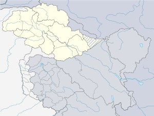
 Sermik Location in the Gilgit Baltistan region  Sermik Sermik (Pakistan) | |
| Coordinates: 35°10′9″N 75°54′23″E | |
| Country | |
| Region | Gilgit-Baltistan |
| District | Skardu |
| Time zone | PST |
| • Summer (DST) | GMT+5:00 |
Geography
Sermik lies in the Sermik Valley on the western side of the Indus River, approximately 37 miles (60 km) by road southeast of Skardu. It lies to the southwest of Keris, to the north of Mehdiabad. The road following the Indus to the southeast of Sermik leads to near Hunderman on the Indian border.[1]
There is a branch of the F.G. Boys High School in Sermik.[2] Al-Mashriq Public School was established in 1996 by NGO EASTS (Educational & Social Team Services).[3]
There are rock paintings at Chaghe Bress above Sermik Dam and Hydro Power Station in the vicinity.[4]
gollark: Or multiple channels.
gollark: How do they accidentally start streaming TV at you?
gollark: ... why?
gollark: I have iptables and ipchairs.
gollark: It doesn't, actually.
References
- Sermik, Google Maps
- "Institution names". Federal Board of Intermediate and Secondary Education, Islamabad. Retrieved 5 February 2020.
- "Al-Mashriq Public School Sermik (AlMPS), Sermik". Crossroads Global Hand. Retrieved 5 February 2020.
- "Journal of Asian Civilisations, Volume 23". Taxila Institute of Asian Civilizations. 2000. p. 233.
This article is issued from Wikipedia. The text is licensed under Creative Commons - Attribution - Sharealike. Additional terms may apply for the media files.