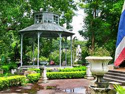
Saranrom Park
Saranrom Park (Thai: สวนสราญรมย์) is a public park in Bangkok. It is located opposite the Grand Palace, between Sanam Chai, Charoen Krung and Rachini roads in Phra Nakhon District. The park occupies the former grounds of Saranrom Palace, which was built in 1866 and served as the residences of several princes and royal guests. The palace gardens were converted to serve as a public park under the Bangkok Metropolitan Administration in 1960.[1]

History
In the past Saranrom Park was the part of Saranrom Palace which was established in 1874 by King Chulalongkorn (RamaV) on the advice of Henry Alabaster who desired this park to be similar to other country.[2] It was decorated by fountains, garden flowers, orchids, perennial plant especially “red roses” which were a favorite flowers of Rama V and there are bird cages and animal cages in the park at that moment. Later in 1904, King Vajiravudh (Rama VI) used this park to train military skills to royal guard and was center place for tradition and culture. This place held “winter events” once during Rama VI reign and in 1932 King Prajadhipok (Rama VII) changed this place to be a location of “Khana Ratsadon” club. Later in 3 June 1960 this park was donated by government to Bangkok to be a public place for people in Bangkok.[1]
Nearby places
Saranrom Park is located near temples and palaces for example, Wat Pho which is popular place for tourists, Wat Rat Pradit Sathit Maha Simaram and Saranrom Palace[3]
References
- "สวนสราญรมย์" [Saranrom Park]. Public Park Office website (in Thai). Bangkok Metropolitan Administration. Retrieved 1 February 2017.
- EDTguide.com. "สวนสราญรมย์ (พระราชอุทยานสราญรมย์)". edtguide (in Thai). Retrieved 2017-11-14.
- "Google Maps". Google Maps. Retrieved 2017-11-14.