Sancey-le-Grand
Sancey-le-Grand is a former commune in the Doubs department in the Bourgogne-Franche-Comté region in eastern France. On 1 January 2016, it was merged into the new commune Sancey.[2]
| Year | Pop. | ±% |
|---|---|---|
| 1793 | 899 | — |
| 1800 | 747 | −16.9% |
| 1806 | 676 | −9.5% |
| 1821 | 933 | +38.0% |
| 1831 | 1,001 | +7.3% |
| 1836 | 1,036 | +3.5% |
| 1841 | 957 | −7.6% |
| 1846 | 960 | +0.3% |
| 1851 | 960 | +0.0% |
| 1856 | 935 | −2.6% |
| 1861 | 952 | +1.8% |
| 1866 | 945 | −0.7% |
| 1872 | 878 | −7.1% |
| 1876 | 815 | −7.2% |
| 1881 | 822 | +0.9% |
| 1886 | 852 | +3.6% |
| 1891 | 856 | +0.5% |
| 1896 | 889 | +3.9% |
| 1901 | 828 | −6.9% |
| 1906 | 802 | −3.1% |
| 1911 | 792 | −1.2% |
| 1921 | 669 | −15.5% |
| 1926 | 688 | +2.8% |
| 1931 | 675 | −1.9% |
| 1936 | 658 | −2.5% |
| 1946 | 665 | +1.1% |
| 1954 | 674 | +1.4% |
| 1962 | 786 | +16.6% |
| 1968 | 753 | −4.2% |
| 1975 | 839 | +11.4% |
| 1982 | 1,020 | +21.6% |
| 1990 | 1,091 | +7.0% |
| 1999 | 1,021 | −6.4% |
| 2004 | 1,058 | +3.6% |
| 2012 | 925 | −12.6% |
| Source: Cassini-EHESS[3] | ||
Sancey-le-Grand | |
|---|---|
Part of Sancey | |
 | |
 Coat of arms | |
Location of Sancey-le-Grand 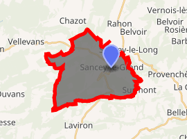
| |
 Sancey-le-Grand  Sancey-le-Grand | |
| Coordinates: 47°17′41″N 6°34′59″E | |
| Country | France |
| Region | Bourgogne-Franche-Comté |
| Department | Doubs |
| Arrondissement | Montbéliard |
| Canton | Bavans |
| Commune | Sancey |
| Area 1 | 23.55 km2 (9.09 sq mi) |
| Population (2013)[1] | 930 |
| • Density | 39/km2 (100/sq mi) |
| Time zone | UTC+01:00 (CET) |
| • Summer (DST) | UTC+02:00 (CEST) |
| Postal code | 25430 |
| Elevation | 461–800 m (1,512–2,625 ft) |
| 1 French Land Register data, which excludes lakes, ponds, glaciers > 1 km2 (0.386 sq mi or 247 acres) and river estuaries. | |
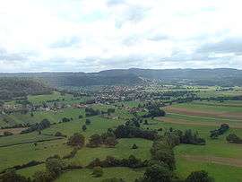
Geography
The commune lies on the first plateau of the Doubs River 55 km (34 mi) northeast of Besançon and 45 km (28 mi) southeast of Montbéliard.
gollark: Use my nickname!
gollark: ```haskellroomName = "recursion " ++ roomName ++ " room"```
gollark: <@240517342189191168> rust.
gollark: <@337621533369303042> rust
gollark: <@341618941317349376> <@341618941317349376> <@341618941317349376> <@341618941317349376> nope. <@341618941317349376> <@341618941317349376>
References
- Populations légales 2013: Téléchargement du fichier d'ensemble, INSEE
- Arrêté préfectoral 23 September 2015 (in French)
- "Notice communale Sancey-le-Grand".
External links
| Wikimedia Commons has media related to Sancey-le-Grand. |
- Sancey-le-Grand on the regional Web site (in French)
| Authority control |
|
|---|
This article is issued from Wikipedia. The text is licensed under Creative Commons - Attribution - Sharealike. Additional terms may apply for the media files.