Salt River (Missouri)
The Salt River is a tributary of the Mississippi River in eastern Missouri in the United States. The river is approximately 55 miles (89 km) long and drains an area of 2,518 sq mi (6,520 km2) in parts of twelve Missouri counties.[4]
| Salt River | |
|---|---|
 | |
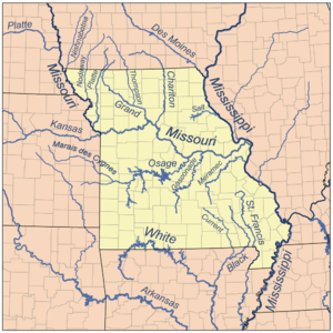 Map showing major rivers in the state of Missouri. The Salt River is at the upper right near the Mississippi River. | |
| Location | |
| Country | United States |
| State | Missouri |
| Physical characteristics | |
| Source | Mark Twain Lake |
| • location | Florida, Monroe County |
| • coordinates | 39°30′07″N 91°46′51″W[1] |
| • elevation | 607 ft (185 m) |
| Mouth | Mississippi River |
• location | Louisiana, Pike County |
• coordinates | 39°28′00″N 91°03′48″W[1] |
• elevation | 449 ft (137 m) |
| Length | 55 mi (89 km) |
| Basin size | 2,518 sq mi (6,520 km2) |
| Discharge | |
| • location | New London, MO[2] |
| • average | 2,120 cu ft/s (60 m3/s)[3] |
| • minimum | 9.5 cu ft/s (0.27 m3/s) |
| • maximum | 107,000 cu ft/s (3,000 m3/s) |
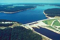
It rises at the confluence of the North, Middle, and South Forks in Monroe County.[5] Since Clarence Cannon Dam construction was completed in 1983, the first 15 miles of the Salt River after the confluence of the North, Middle, and South Fork have been contained in Mark Twain Lake. Below the dam, the river winds generally east for 63 miles through a rural valley surrounded by low bluffs. Below New London, it receives Spencer and Peno Creeks from the right. The Salt joins the Mississippi River at Ted Shanks Wildlife Conservation Area (River Mile 284) just one mile north of US Route 54 bridge in Louisiana in Pike County.[6][7]
The river was called "Ohaha" by the Native Americans that once lived along its course.[1] It was also known as "the river Jeffreon" in the 1804 Treaty of St. Louis. American author Mark Twain was born in the town of Florida on the Salt River in 1835.[8]
| River | Location | Discharge |
|---|---|---|
| North Fork Salt River | Shelbina | 255 cu/ft. per sec.[9] |
| Elk Fork Salt River | Paris | 202 cu/ft. per sec.[10] |
| Middle Fork Salt River | Paris | 457 cu/ft. per sec.[11] |
| South Fork Salt River | Santa Fe | 313 cu/ft. per sec.[12] |
See also
References
- "Salt River". Geographic Names Information System. United States Geological Survey. 1980-10-24. Retrieved 2012-01-20.
- "USGS Gage #05508000 on the Salt River near New London, MO: Water-Data Report 2011" (PDF). National Water Information System. U.S. Geological Survey. 1980–2011. Retrieved 2012-01-20.
- "USGS Gage #05508000 on the Salt River near New London, MO: Water-Data Report 2011" (PDF). National Water Information System. U.S. Geological Survey. 1980–2011. Retrieved 2012-01-20.
- "Salt River/Mark Twain Reservoir, Missouri" (PDF). CEAP Project Plan. USDA Natural Resources Conservation Service. 2005-02-07. Retrieved 2012-01-20.
- Missouri Department of Conservation. "Salt River - Geography". Archived from the original on 31 August 2013. Retrieved 18 April 2013.
- Missouri Atlas & Gazetteer, DeLorme, 1998, First edition, p. 33 ISBN 0-89933-224-2
- Louisiana, Missouri 7.5 Minute Topographic Quadrangle, USGS, 1978
- "Mark Twain Birthplace State Historic Site – General Information". Missouri State Parks. Retrieved 2012-01-20.
- Waterdata USGS
- Waterdata USGS
- Waterdata USGS
- Waterdata USGS