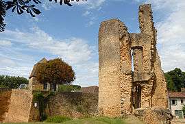
Sainte-Alvère
Sainte-Alvère is a former commune in the Dordogne department in southwestern France. On 1 January 2016, it was merged into the new commune Sainte-Alvère-Saint-Laurent-les-Bâtons,[2] which merged into the new commune Val de Louyre et Caudeau on 1 January 2017.
Sainte-Alvère | |
|---|---|
Part of Val de Louyre et Caudeau | |
 | |
 Coat of arms | |
Location of Sainte-Alvère 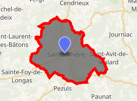
| |
 Sainte-Alvère  Sainte-Alvère | |
| Coordinates: 44°56′51″N 0°48′34″E | |
| Country | France |
| Region | Nouvelle-Aquitaine |
| Department | Dordogne |
| Arrondissement | Périgueux |
| Canton | Périgord central |
| Commune | Val de Louyre et Caudeau |
| Area 1 | 32.42 km2 (12.52 sq mi) |
| Population (2017)[1] | 791 |
| • Density | 24/km2 (63/sq mi) |
| Time zone | UTC+01:00 (CET) |
| • Summer (DST) | UTC+02:00 (CEST) |
| Postal code | 24510 |
| Elevation | 105–251 m (344–823 ft) (avg. 284 m or 932 ft) |
| 1 French Land Register data, which excludes lakes, ponds, glaciers > 1 km2 (0.386 sq mi or 247 acres) and river estuaries. | |
Population
| Year | Pop. | ±% |
|---|---|---|
| 1962 | 827 | — |
| 1968 | 798 | −3.5% |
| 1975 | 745 | −6.6% |
| 1982 | 710 | −4.7% |
| 1990 | 756 | +6.5% |
| 1999 | 782 | +3.4% |
| 2008 | 812 | +3.8% |
gollark: We're very broadband™.
gollark: We emit nonradio electromagnetic radiation too.
gollark: That's not true.
gollark: osmarkscalculator™ has one way to do things, but the way is really stupid.
gollark: Or osmarkscalculator™.
See also
References
- Téléchargement du fichier d'ensemble des populations légales en 2017, INSEE
- Arrêté préfectoral 22 October 2015 (in French)
| Wikimedia Commons has media related to Sainte-Alvère. |
| Authority control |
|
|---|
This article is issued from Wikipedia. The text is licensed under Creative Commons - Attribution - Sharealike. Additional terms may apply for the media files.