Saint Arnaud Range
The Saint Arnaud Range is a mountain range in the central north of New Zealand's South Island. It lies between Lake Rotoiti and the upper reaches of the Wairau River, and marks the eastern boundary of Nelson Lakes National Park.
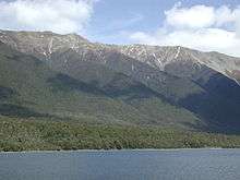
The mountains seen from the west across Lake Rotoiti
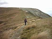
Alpine area just west of the St Arnaud Range
The lower elevations are covered primarily in beech forests, while higher elevations (above about 5,000 feet) are alpine.
The name of the range commemorates the French Marshal Jacques Leroy de Saint-Arnaud (1798-1854).
Recreation
The St Arnaud track ascends the western side of the range from the village of Saint Arnaud (about 3 hours climb).[1]
The Rainbow Ski Area is on the eastern side of the range.
gollark: It comes with everything necessary shipped except for the config DB.
gollark: https://git.osmarks.net/osmarks/onstat
gollark: There was somehow no good software for it.
gollark: OnStat™, for detecting if osmarks.net implodes.
gollark: I'll stick it on git.osmarks.net.
References
| Wikimedia Commons has media related to Category:Saint Arnaud Range. |
- Archived 2008-10-15 at the Wayback Machine Department of Conservation.
This article is issued from Wikipedia. The text is licensed under Creative Commons - Attribution - Sharealike. Additional terms may apply for the media files.