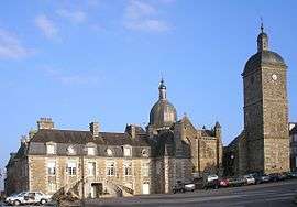
Saint-Sever-Calvados
Saint-Sever-Calvados is a former commune in the Calvados department in the Normandy region in northwestern France. On 1 January 2017, it was merged into the new commune Noues de Sienne.[2]
Saint-Sever-Calvados | |
|---|---|
Part of Noues de Sienne | |
 | |
.svg.png) Coat of arms | |
Location of Saint-Sever-Calvados 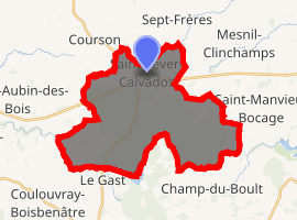
| |
 Saint-Sever-Calvados  Saint-Sever-Calvados | |
| Coordinates: 48°50′28″N 1°02′47″W | |
| Country | France |
| Region | Normandy |
| Department | Calvados |
| Arrondissement | Vire |
| Canton | Vire |
| Commune | Noues de Sienne |
| Area 1 | 27.92 km2 (10.78 sq mi) |
| Population (2017)[1] | 1,163 |
| • Density | 42/km2 (110/sq mi) |
| Time zone | UTC+01:00 (CET) |
| • Summer (DST) | UTC+02:00 (CEST) |
| Postal code | 14380 |
| Elevation | 144–350 m (472–1,148 ft) (avg. 243 m or 797 ft) |
| 1 French Land Register data, which excludes lakes, ponds, glaciers > 1 km2 (0.386 sq mi or 247 acres) and river estuaries. | |
Geography
The former French commune covered 2,792 hectares, a high proportion of it being the Saint-Sever forest. The Saint-Sever forest is the source of two rivers, the river Vire and the river Siena. Lorencières, at the south of the area is highest point at about 350 metres, and the lowest, at the north east area of the at about 144 metres. The south of the area is on the granite massif of Vire-Carolles, and the north on the schistous basement of the basin Bocage virious. The average rainfall is 1,150 mm.[3]
The places within the area are: la Bersairie, les Déserts, la Braiserie, Saint-Blaise, la Caverie, les Broderies, la Lande, le Bourg (au nord), la Guertière, la Guibellière, la Bunoudière, la Basse Fosse, la Haute Fosse, le Mouton, les Houlettes, le Beauregard, la Maquellerie, le Souchet, la Jourdanière, les Closets, le Vieux Château, le Clos, la Clairière, la Davière, la Faverie, la Jardière, la Rigoussière, la Quetterie, la Nellerie, la Vermondière, la Clergerie (à l'est), la Tournerie, le Mesnil, la Mennetière, la Jancellière, la Capucière, les Lorencières, la Noue de Sienne, l'Ermitage (au sud), le Valet, Brundou, la Jouardière, la Reinière, la Guermonderie, la Pédevinière, les Rivages, Cotigny, Plate Bourse, le Clos du Pôt, la Fieffe, la Porte de Cotigny, la Gablerie, le Bois de Cotigny, le Courbillon (à l'ouest) and le Richelieu[3]
The town of Saint-Sever-Calvados is situated 13 Km west of Vire and 14 Km east of Villedieu-les-Poêles, and on a major road between these locations.[3]
Population
| Year | Pop. | ±% |
|---|---|---|
| 1793 | 1,539 | — |
| 1800 | 1,527 | −0.8% |
| 1806 | 1,512 | −1.0% |
| 1821 | 1,515 | +0.2% |
| 1831 | 1,653 | +9.1% |
| 1836 | 1,685 | +1.9% |
| 1841 | 1,658 | −1.6% |
| 1846 | 1,608 | −3.0% |
| 1851 | 1,630 | +1.4% |
| 1856 | 1,551 | −4.8% |
| 1861 | 1,507 | −2.8% |
| 1866 | 1,517 | +0.7% |
| 1872 | 1,526 | +0.6% |
| 1876 | 1,540 | +0.9% |
| 1881 | 1,554 | +0.9% |
| 1886 | 1,514 | −2.6% |
| 1891 | 1,512 | −0.1% |
| 1896 | 1,338 | −11.5% |
| 1901 | 1,387 | +3.7% |
| 1906 | 1,456 | +5.0% |
| 1911 | 1,472 | +1.1% |
| 1921 | 1,335 | −9.3% |
| 1926 | 1,400 | +4.9% |
| 1931 | 1,539 | +9.9% |
| 1936 | 1,704 | +10.7% |
| 1946 | 1,680 | −1.4% |
| 1954 | 1,566 | −6.8% |
| 1962 | 1,485 | −5.2% |
| 1968 | 1,415 | −4.7% |
| 1975 | 1,379 | −2.5% |
| 1982 | 1,425 | +3.3% |
| 1990 | 1,409 | −1.1% |
| 1999 | 1,325 | −6.0% |
| 2008 | 1,369 | +3.3% |
International relations
The commune is twinned with:
- Niederdorfelden, Germany since 1973.
See also
References
- Téléchargement du fichier d'ensemble des populations légales en 2017, INSEE
- Arrêté préfectoral 6 December 2016 (in French)
- "Géoportail". www.geoportail.gouv.fr. Retrieved 2018-06-22.
| Wikimedia Commons has media related to Saint-Sever-Calvados. |
| Authority control |
|
|---|