Saint-Pantaléon, Lot
Saint-Pantaléon (Languedocien: Sent Pantaleon) is a former commune in the Lot department in south-western France. On 1 January 2019, it was merged into the new commune Barguelonne-en-Quercy.[2]
Saint-Pantaléon | |
|---|---|
Part of Barguelonne-en-Quercy | |
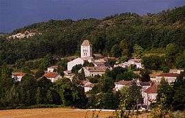 A general view of Saint-Pantaléon | |
Location of Saint-Pantaléon 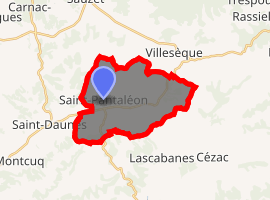
| |
 Saint-Pantaléon  Saint-Pantaléon | |
| Coordinates: 44°22′09″N 1°16′00″E | |
| Country | France |
| Region | Occitanie |
| Department | Lot |
| Arrondissement | Cahors |
| Canton | Luzech |
| Commune | Barguelonne-en-Quercy |
| Area 1 | 19.37 km2 (7.48 sq mi) |
| Population (2017)[1] | 270 |
| • Density | 14/km2 (36/sq mi) |
| Time zone | UTC+01:00 (CET) |
| • Summer (DST) | UTC+02:00 (CEST) |
| Postal code | 46800 |
| Elevation | 175–305 m (574–1,001 ft) (avg. 193 m or 633 ft) |
| 1 French Land Register data, which excludes lakes, ponds, glaciers > 1 km2 (0.386 sq mi or 247 acres) and river estuaries. | |
Geography
The village lies in the valley of the ruisseau de Fraysse, a tributary of the Barguelonnette, which flows southwestward through the commune.
gollark: Yes, there's lots of caching.
gollark: There's no C++ page in Minoteaur 6.
gollark: I must admit, the Minoteaur login page was a glorious and wonderful design, by me.
gollark: https://minoteaur.osmarks.net/login?redirect=%2Flist_of_isomorphisms_to_bee
gollark: It works fine. You're just wrong.
See also
References
- Téléchargement du fichier d'ensemble des populations légales en 2017, INSEE
- Arrêté préfectoral 28 September 2018 (in French)
| Wikimedia Commons has media related to Saint-Pantaléon (Lot). |
| Authority control |
|
|---|
This article is issued from Wikipedia. The text is licensed under Creative Commons - Attribution - Sharealike. Additional terms may apply for the media files.