Saint-Julien-d'Arpaon
Saint-Julien-d'Arpaon is a former commune in the Lozère department in southern France. On 1 January 2016, it was merged into the new commune of Cans-et-Cévennes.[2] Its population was 91 in 2017.[1]
Saint-Julien-d'Arpaon | |
|---|---|
Part of Cans-et-Cévennes | |
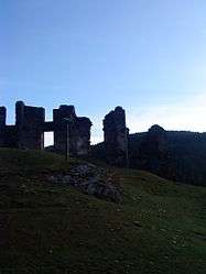 The ruins of the château in Saint-Julien-d'Arpaon | |
Location of Saint-Julien-d'Arpaon 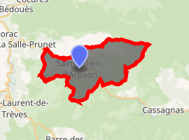
| |
 Saint-Julien-d'Arpaon  Saint-Julien-d'Arpaon | |
| Coordinates: 44°18′01″N 3°39′59″E | |
| Country | France |
| Region | Occitanie |
| Department | Lozère |
| Arrondissement | Florac |
| Canton | Le Collet-de-Dèze |
| Commune | Cans-et-Cévennes |
| Area 1 | 20.72 km2 (8.00 sq mi) |
| Population (2017)[1] | 91 |
| • Density | 4.4/km2 (11/sq mi) |
| Time zone | UTC+01:00 (CET) |
| • Summer (DST) | UTC+02:00 (CEST) |
| Postal code | 48400 |
| Elevation | 580–1,421 m (1,903–4,662 ft) (avg. 610 m or 2,000 ft) |
| 1 French Land Register data, which excludes lakes, ponds, glaciers > 1 km2 (0.386 sq mi or 247 acres) and river estuaries. | |
Saint-Julien-d'Arpaon stands at a crossing of the River Mimente on the Robert Louis Stevenson Trail (GR 70), a popular long-distance path following approximately the route travelled by Robert Louis Stevenson in 1878 and described in his book Travels with a Donkey in the Cévennes.[3] Stevenson mentions the village and its ruined chateau in passing, though not by name:
...the road passed hard by two black hamlets, one with an old castle atop to please the heart of the tourist.[4]
See also
References
- Téléchargement du fichier d'ensemble des populations légales en 2017, INSEE
- Arrêté préfectoral 2–14 December 2015
- Castle, Alan (2007). The Robert Louis Stevenson Trail (2nd ed.). Cicerone. pp. 129–127. ISBN 978-1-85284-511-7.
- Stevenson, Robert Louis (1905) [1879]. . Travels with a Donkey in the Cevennes. New York: Charles Scribner's Sons. p. – via Wikisource.
| Wikimedia Commons has media related to Saint-Julien-d'Arpaon. |
| Authority control |
|
|---|
This article is issued from Wikipedia. The text is licensed under Creative Commons - Attribution - Sharealike. Additional terms may apply for the media files.