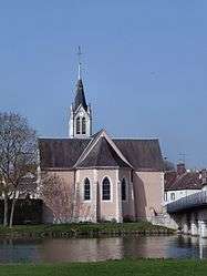
Saint-Denis-les-Ponts
Saint-Denis-les-Ponts is a former commune in the Eure-et-Loir department in northern France. On 1 January 2019, it was merged into the new commune Saint-Denis-Lanneray.[2]
Saint-Denis-les-Ponts | |
|---|---|
Part of Saint-Denis-Lanneray | |
 | |
Location of Saint-Denis-les-Ponts 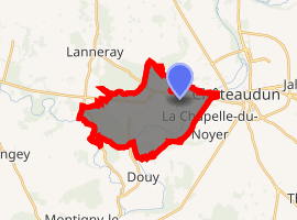
| |
 Saint-Denis-les-Ponts  Saint-Denis-les-Ponts | |
| Coordinates: 48°04′06″N 1°17′38″E | |
| Country | France |
| Region | Centre-Val de Loire |
| Department | Eure-et-Loir |
| Arrondissement | Châteaudun |
| Canton | Châteaudun |
| Commune | Saint-Denis-Lanneray |
| Area 1 | 13.8 km2 (5.3 sq mi) |
| Population (2017)[1] | 1,688 |
| • Density | 120/km2 (320/sq mi) |
| Time zone | UTC+01:00 (CET) |
| • Summer (DST) | UTC+02:00 (CEST) |
| Postal code | 28200 |
| Elevation | 100–152 m (328–499 ft) (avg. 124 m or 407 ft) |
| 1 French Land Register data, which excludes lakes, ponds, glaciers > 1 km2 (0.386 sq mi or 247 acres) and river estuaries. | |
Population
| Year | Pop. | ±% |
|---|---|---|
| 1793 | 700 | — |
| 1800 | 718 | +2.6% |
| 1806 | 730 | +1.7% |
| 1821 | 891 | +22.1% |
| 1831 | 897 | +0.7% |
| 1836 | 824 | −8.1% |
| 1841 | 831 | +0.8% |
| 1846 | 942 | +13.4% |
| 1851 | 911 | −3.3% |
| 1856 | 907 | −0.4% |
| 1861 | 885 | −2.4% |
| 1866 | 886 | +0.1% |
| 1872 | 885 | −0.1% |
| 1876 | 885 | +0.0% |
| 1881 | 878 | −0.8% |
| 1886 | 831 | −5.4% |
| 1891 | 806 | −3.0% |
| 1896 | 816 | +1.2% |
| 1901 | 835 | +2.3% |
| 1906 | 784 | −6.1% |
| 1911 | 780 | −0.5% |
| 1921 | 674 | −13.6% |
| 1926 | 662 | −1.8% |
| 1931 | 651 | −1.7% |
| 1936 | 602 | −7.5% |
| 1946 | 730 | +21.3% |
| 1954 | 771 | +5.6% |
| 1962 | 846 | +9.7% |
| 1968 | 1,008 | +19.1% |
| 1975 | 1,539 | +52.7% |
| 1982 | 1,716 | +11.5% |
| 1990 | 1,567 | −8.7% |
| 1999 | 1,544 | −1.5% |
| 2008 | 1,825 | +18.2% |
gollark: There are weird visual quirks like this: https://en.wikipedia.org/wiki/McCollough_effect which persist for a while.
gollark: That's not actually guaranteed either.
gollark: Actually, you can, but only in bizarrely specific ways.
gollark: Well, consciousness/abstract reasoning/etc.
gollark: "You" are some specific brain modules which handle consciousness and language and whatever; it's hardly guaranteed that you have write access to everything else.
References
- Téléchargement du fichier d'ensemble des populations légales en 2017, INSEE
- Arrêté préfectoral 31 July 2018 (in French)
| Wikimedia Commons has media related to Saint-Denis-les-Ponts. |
| Authority control |
|
|---|
This article is issued from Wikipedia. The text is licensed under Creative Commons - Attribution - Sharealike. Additional terms may apply for the media files.