Saint-Étienne-en-Dévoluy
Saint-Étienne-en-Dévoluy is a former commune in the Hautes-Alpes department in southeastern France. On 1 January 2013, Agnières-en-Dévoluy, La Cluse, Saint-Disdier, and Saint-Étienne-en-Dévoluy amalgamated into the new commune of Le Dévoluy.
Saint-Étienne-en-Dévoluy | |
|---|---|
Part of Le Dévoluy | |
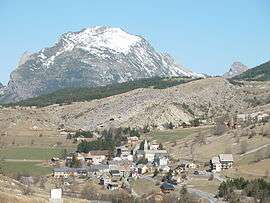 The village of Saint-Étienne-en-Dévoluy, with the south face of Le Gicon in the background | |
 Coat of arms | |
Location of Saint-Étienne-en-Dévoluy 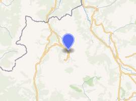
| |
 Saint-Étienne-en-Dévoluy  Saint-Étienne-en-Dévoluy | |
| Coordinates: 44°41′36″N 5°56′31″E | |
| Country | France |
| Region | Provence-Alpes-Côte d'Azur |
| Department | Hautes-Alpes |
| Arrondissement | Gap |
| Canton | Saint-Étienne-en-Dévoluy |
| Commune | Le Dévoluy |
| Area 1 | 67.87 km2 (26.20 sq mi) |
| Population (2017)[1] | 502 |
| • Density | 7.4/km2 (19/sq mi) |
| Time zone | UTC+01:00 (CET) |
| • Summer (DST) | UTC+02:00 (CEST) |
| Postal code | 05250 |
| Elevation | 1,134–2,652 m (3,720–8,701 ft) (avg. 1,263 m or 4,144 ft) |
| 1 French Land Register data, which excludes lakes, ponds, glaciers > 1 km2 (0.386 sq mi or 247 acres) and river estuaries. | |
SuperDévoluy, a ski resort, was part of the commune.
Population
| Year | Pop. | ±% |
|---|---|---|
| 1962 | 385 | — |
| 1968 | 417 | +8.3% |
| 1975 | 471 | +12.9% |
| 1982 | 527 | +11.9% |
| 1990 | 538 | +2.1% |
| 1999 | 538 | +0.0% |
| 2008 | 573 | +6.5% |
gollark: Hey, maybe it could do OCR too.
gollark: It was a 99% match. If you want the new text variant to not be detected as a repost you'd basically ignore most slightly tweaked reposts.
gollark: I have some ideas I'll try for getting around it tomorrow.
gollark: Remove borders and downscale it a lot?
gollark: The DCT thing can apparently let it ignore small changes fine but can't deal with big ones like cropping.
This article is issued from Wikipedia. The text is licensed under Creative Commons - Attribution - Sharealike. Additional terms may apply for the media files.