Südschleife
The Nürburgring Südschleife (south loop) was a German motor racing circuit which was built in 1927 at the same time as the world-famous Nürburgring Nordschleife (north loop).
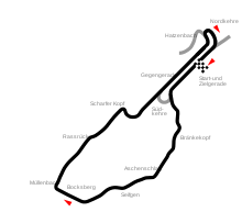
The Südschleife and Nordschleife layouts were joined together by the Start und Ziel (start/finish) area, and could therefore be driven as one track that was over 28 kilometres (17 mi) long. Races were held at the combined layout only until 1931. The Südschleife was used for the ADAC Eifelrennen from 1928 until 1931 and from 1958 until 1968, as well as for the Eifelpokal and other minor races.
The Südschleife was rarely used after the Nordschleife was rebuilt and updated in 1970 and 1971, and was finally destroyed by the building of the current Nürburgring Grand Prix circuit in the early 1980s. Today only small sections of the original track remain.
Track description
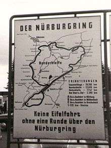
The shared start/finish area of the Nürburgring complex consisted of two back-to-back straights joined together at the southern end by a tight loop. The entrance to the 7.5 kilometres (4.7 mi) Südschleife lay on the outside edge of this hairpin and was signposted as the road to Bonn. It immediately dropped sharply downhill and under a public road before winding through a heavily-wooded section.
Tight corners soon gave way to fast downhill sections with flowing bends until, at the outskirts of the nearby town of Müllenbach, the track turned sharply right northwards and began a long climb up the hill.
At the end of this run came a right hairpin turn which led to a long left curve around the bottom of a hill. This led onto the back straight of the start/finish area. At this point it was possible to continue onto the Nordschleife or take two sharp right-hand turns in order to enter the starting straight once again.
Photographs of the track in use show that trees and hedges were not cut back in many areas, being allowed to grow right up to the trackside. Although the Nordschleife had very little in the way of run-off areas, the Südschleife seems to have had none at all, which was likely to have been a factor in the choice of circuit for major events.
Stichstraße shortcut
In 1938 a small section of new track (the Stichstraße) was laid which allowed drivers nearing the end of the Südschleife to bypass the start/finish straights and take a right turn which led back to the start of the downhill twists. This shortened a lap to around 5.7 kilometres (3.5 mi). This layout was used for tourist rides and for testing.
Popularity
The track's "big brother", the Nordschleife, was much longer and more challenging and so naturally became more famous and more favoured. Throughout its lifetime, the Südschleife was rarely used for major events. In the early days, the full twin-ring layout (the Gesamtstrecke) was used for the big races but soon the Südschleife was relegated to relatively small events and testing sessions.
Sections of routes
| km | Section |
|---|---|
| 0 | Start and finish |
| Connection south sweep | |
| 1 | |
| Bränkekopf | |
| 2 | Aschenschlag |
| Seifgen | |
| 3 | |
| Bocksberg | |
| 4 | Müllenbach |
| Rassrück | |
| 5 | |
| Scharfer Kopf | |
| 6 | |
| Gegengerade | |
| 7 | |
| Nordkehre | |
| 7,747 | Start and finish |
The route sections bore the following names, among others Bränkekopf, Aschenschlag, Seifgen, Bocksberg, Müllenbach und Scharfer Kopf.
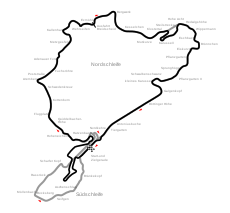 The position of the south loop compared to the current GP track
 Route of the south loop 1927-1972
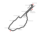 Modified connection Südschleife from 1973
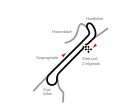 The start and finish loop with the south and north turn
Lap record
The lap record on the Südschleife is held by Helmut Kelleners with 2:38.6 minutes = 175.85 km/h, driven with a March 707 in the CanAm run of the 3rd International AvD SCM circuit race on 18 October 1970.[1] Previous record holder was Brian Redman, who achieved 2:47.0 minutes = 161.03 km/h in the Formula 2 race on 21 April 1968 with a Ferrari.[2]
Public access
The entire Nürburgring Gesamtstrecke was open to the public from its initial opening. At several points around the circuit there were access roads and toll points from which drivers and riders could begin or end a drive. The Südschleife had one of these at the bottom of the uphill stretch near Müllenbach. More information on this can be found in the public access section of the main Nürburgring article.
Remaining sections
The current Grand Prix circuit required the complete destruction of the start/finish area but at a point around 1 km (0.62 mi) into the Südschleife, a modern public road now follows the route, although the bends have been eased and the vegetation does not come as close to the road as it did when the track was open.
This public road continues into the town of Müllenbach but leaves the route of the old track on the outskirts. Nothing remains of the famous corners there.
The road up the hill still exists and is sometimes used to allow access to parking areas for the Grand Prix track. The lower sections are no longer maintained.
References
- "3. Int. SCM Rundstreckenrennen 1970". 2005-02-10. Archived from the original on 2005-02-10. Retrieved 2020-05-07.
- ADAC-Eifelrennen [die Geschichte der traditionsreichsten Motorsportveranstaltung Deutschlands seit 1922]. Behrndt, Michael, 1953-, Födisch, Jörg-Thomas, 1947-, Behrndt, Matthias, 1980-. Königswinter: Heel. 2009. ISBN 978-3-86852-070-5. OCLC 458746509.CS1 maint: others (link)